Tag Archives: ruins

Tunisia

Tunisia is the northernmost country in Africa with a population of a little over 12 million. It is bordered by Algeria (west), Libya (southeast) and the Mediterranean Sea to the north and east. It also shares maritime borders with Italy and Malta.

Like most of the nations around the Mediterranean it has a long and potted history about who controlled the area that is now Tunisia. And this recorded history starts with the Berbers before the 12th century BC. In 146 BC the Romans defeated the city of Carthage and had control of the place for the next 800 odd years. In the 7th century AD, Arab Muslims had their turn and conquered Tunisia, moving in in huge numbers over the next few hundred years. In 1546, the Ottoman Empire took control for the next 300 years, until 1881, when the French conquered Tunisia. In 1956, Tunisia finally gained independence as the Tunisian Republic.

Tunisia has odd currency laws and will confiscate cash if you get them wrong.

Most countries allow you in and out of the country with the equivalent of USD $10,000 and more so long as you declare it.

But not here.

  • Here you are allowed to bring in 10,000 dinar (about $3300 USD) and
  • must declare amounts over 5000 dinar.
  • It is a criminal offence to export Tunisian dinar
  • so make sure you change everything back before you leave
  • any unchanged dinar will be confiscated
  • Anything over the 5000 dinar (equivalent) will be confiscated
  • about USD $1500 or 1300 euros

We found this out the hard way when I got my bag deconstructed by the agent (on the way out of the country) looking for cash. In essence, if I had any Dinar left over or more than about USD 1500 or 1300 euros in cash on me, they were within their rights to confiscate it from me. There are grounds to get it back if you get a receipt and return to the country within 3 months. However, nobody who had tried this (based on online commentary) could locate where the money could be collected from due to Bureaucratic runaround.

Tunis

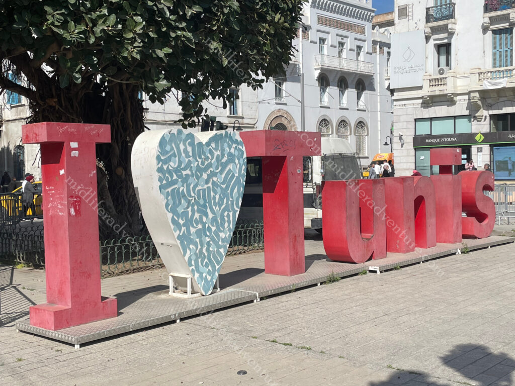
Tunis is the largest and capital city of Tunisia with about 2.7 million residents in the greater Tunis area.

And is a great place to kick back and chill.

The biggest surprise for me was the cab drivers. As any regular traveller knows, cab drivers in almost every nation are as sketchy as hell and are always trying to rip you off. Yes, there are some exceptions, but for the most part, we have stopped using taxis (even in Australia) in favour of ride-share apps.

But that was not the case here. The cabs all used meters, without being asked, were reasonably priced and did not try and tout and prey upon unsuspecting tourists. A refreshing and pleasant change.

The Tunis Medina is (apparently) the best preserved in all of North Africa. It is the historical and cultural heart of the city, with buildings dating from the 18th and 19th centuries. It is home to the souks, the markets, workshops and ateliers. Allegedly there is a pecking order to such things and therefore they are arranged hierarchically around the Great Mosque.

The souk is nowhere near the bedlam that was Marrakesh, but there is still plenty going on. And the available artisan work is of the highest quality. It is cleaner, quieter, has less touts and is generally much more manageable for the shy tourists.

The Jamaa ez-Zitouna mosque, or ‘olive mosque’, is the oldest in the city. It was founded at the end of the 7th century or in the early 8th century, but its current architectural form dates from a reconstruction in the 9th century. The mosque is said to be one of the most important in all of Islam and covers 5,000 square metres, with nine entrances. The building includes many antique columns reused after the destruction of Carthage. Due to the nearness of the souk in the Medina, you only really get to see some columns and arches.

Being non-Muslims, we typically just admire the outside of mosques and rarely enter. In many cases, we are not allowed in anyway, but even when we are we tend not to. Some of the rooftops around the Medina offer amazing panorama views over the Medina, and some even stay open for after dark shots.

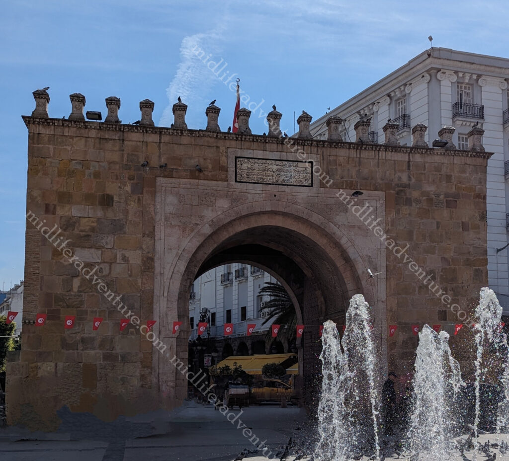
The Sea Gate (also known as the Bab el Bhar and the Porte de France) is the entrance to the Medina from the new part of town.

New Tunis

East of the Medina, is the modern part of the city called “Ville Nouvelle”. This area is often referred to by media and travel guides as “the Tunisian Champs-Élysées. It is a grand avenue lined with colonial-era buildings.

While Tunisia has had its share of security issues over the decades, at no point did we feel unsafe or uneasy. There was an off-putting security presence in the new town area that seemed extremely over the top for what was going on. Armoured vehicles, heavily armed military and blockades were everywhere and there was nothing going on.

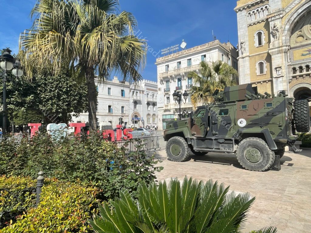
A more timid day I had never seen, clear blue skies and almost nobody on the streets, but the grand avenue had a visibly present and unnecessarily confrontational security presence.

Doors

For some strange reason I found myself taking photos of the doors (especially in the Media) of Tunis. They were truly stunning. Some huge and ornate, while others simple but there was something about the doors in this place that just grabbed me.

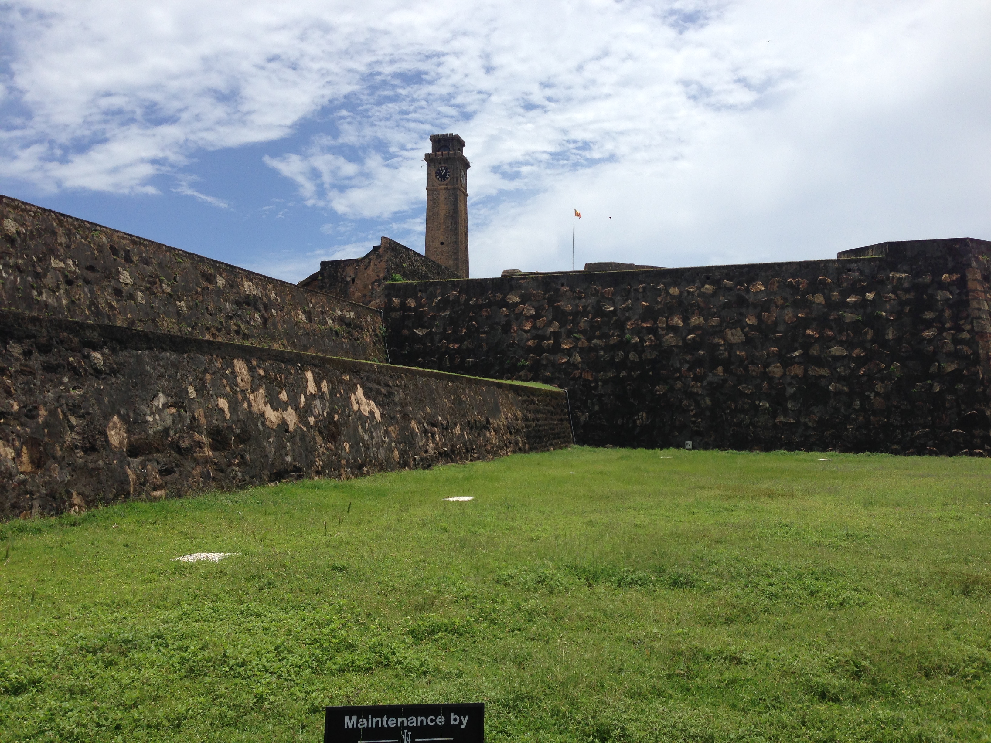
Carthage was a city I had heard mentioned in documentaries and the like, but never really knew where it was or much about is. As it turns out it is here on hte outskirts of Tunis and was one of the most important trading hubs of the Ancient Mediterranean and one of the richest cities of the classical world.

It has a history dating back to the 12th century BC. and between 650 BC to 146 BC, it was the most powerful trading and commercial city in the Mediterranean.

It had a sophisticated 200-dock circular harbor and the funds earned prompted investment in a sprawling metropolis of temples, markets, and estates.

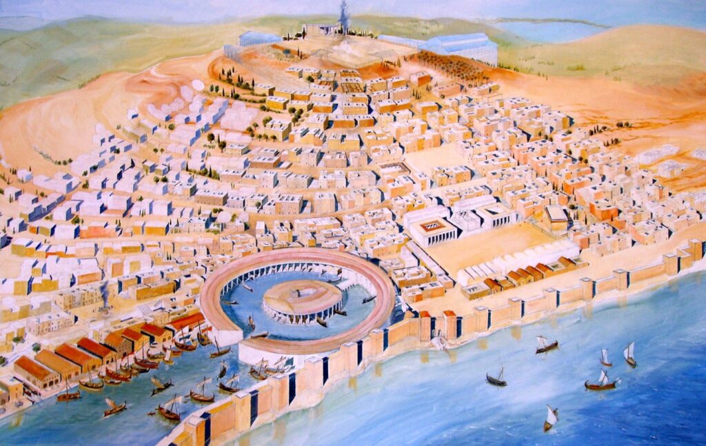
And all of this is just a 20-minute drive outside modern day Tunis. It was quite the sight until 146 BC when the Romans came an lay siege to the place for 3 years.

Today there are 7 main sites that are left to see in Carthage and one ticket ($6 each) will get you into all the sites. The place is about 15-20 km out of town (a $7-8 cab ride) and our (flash) hotel was charging exorbitant rates for their tour (over $150 a head). So we hopped a cab and headed to the ruins.

But be warned the 7 places are a fair distance between each other. We made the mistake of thinking it was like the Roman Forum and was within an easy strolling distance. We got dropped off at the archaeological site and found ourselves stranded.

So we hiked about 1.5km to the Cathedral remains (Saint Cyprien) that were both shut and quite unimpressive. And then another 1.7km walk up to the roman houses and villas. The lady at the gate at the villas entry was busy talking on her phone. So Jill stood in front of her and waited, and waited and put her money on the counter and waited. After quite literally 12 minutes of this, she picked up her money, turned around and walked away. With some choice words.

Unsurprisingly, as soon as she took her money and turned away the girl got off the phone and was ready to serve Jill. Some more choice words and we continued to walk away from her, with some more choice words. About 500m further on we found ourselves at the Roman Amphitheatre where we paid our entry and entered with no issues whatsoever. And across the road was some more ruins.

Another 1.5km walk and we found ourselves atop Byrsa hill at the Saint Louis Cathedral and the acropolis of Byrsa. This is the site of the Carthage Museum and an impressive number of pieces of Roman Columns and the odd statue.

About 2km down the hill was the last of the sights (given that we boycotted the Roman Villas due to the attitude of the girl on the counter) the aqueducts. Built in the 2nd century BC by the emperor Hadrian, they brought water more than 100kms from Zaghouan to Carthage.

Ramadan

For some reason, Jill has taken to booking us into Muslim countries during Ramadan. Last year it was the Maldives and this year it was Morocco and Tunisia and later in Istanbul. This is a forced alcohol detox as the nations typically do not serve alcohol anyway and during the holy month there is no chance.

The other thing it means is that almost every restaurant is closed and by the time the sun goes down, you tend to be a bit peckish. Thankfully we found a little joint that served brilliant local dishes for a song. Our (flash) hotel was offering a set (abridged) menu for 100 dinar ($50) a head, so we hit the streets hunting for better. And did we find it.

A little hole-in-the-wall joint, with a huge upstairs terrace, great food and entertainment for 45 dinars ($22.50) a head. Dinner was salad (more dips really) and bread, traditional soup, and the main (that came cooked and served in a weird shaped pot) was a hearty stew type thing. We went looking the next night for something different but ended up at the same joint and had a seafood main and some form of crispy egg crepe in place of the soup.

We had planned a trip to Dougga, which is lauded as “the best-preserved Roman small town in North Africa”.  But I guess this will sit high on the list of things to do next time we come.

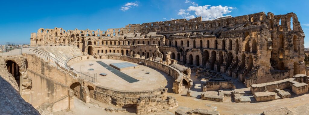
The Amphitheatre of El Jem is an amphitheatre in original town of Thysdrus although now known as El Djem. It was built for the usual roman spectator sports (gladiators etc) around 238 AD and is one of the best preserved stone in the world. It was one of the biggest amphitheatres in the world with an estimated capacity of around 35,000.

And sadly, this is one of the many things that we did not get to. So this (along with a bunch of other reasons) rates as a pretty good reason to come back.

Tunisia was great and there was so much more for us to see and do. It was a great pity that the currency issue as you leave puts a bad taste in your mouth. Other than this we really enjoyed our time here and will be back.

Bolivia

Bolivia is a landlocked country in South America that is bordered Brazil, Paraguay, Argentina, Chile and Peru.

The administrative capital (and seat of government) is La Paz. The constitutional capital is Sucre (the seat of the judiciary). While the largest city and main industrial center is Santa Cruz de la Sierra.

Before Spanish colonisation, the area that is now Bolivia was part of the Inca Empire. But in the 16th century, Spanish conquistadors took control of the region and found it to be rich in silver deposits. Spain built its empire, in large part ,upon the silver that was extracted from Bolivia’s mines.

Bolivia was named after Simón Bolivar (officially José Antonio de la Santísima Trinidad Bolívar Palacios Ponte y Blanco) who was a Venezuelan leader that led the majority of South America (Colombia, Venezuela, Ecuador, Peru, Panama, and Bolivia) to independence from the Spanish Empire. Bolivia gained its independence in 1825.

Lake Titicaca is about the only thing I had heard about from Bolivia and we didn’t get near it. It is the largest lake in South America and sits high in the Andes mountains on the border of Bolivia and Peru. The western part of the lake lies within Peru while the eastern side is located in Bolivia, near La Paz.

Five major river systems feed into Lake Titicaca (Ramis, Coata, Ilave, Huancané, and Suchez) and more than 20 other smaller streams also empty into Titicaca. There are 41 islands on the lake, some of which are densely populated.

Most importantly, Lake Titicaca is the legendary birthplace of the Inca civilization, and is also believed to hold precious Inca treasure.

The other thing that I had seen about Bolivia was about the Yungas Road. This is more commonly known as death road. I had seen documentaries of cars, trucks and buses trying to navigate (and pass each other) on this stretch of road, often in pouring rain, with landslides taking place underneath vehicle tyres. All of this on the side of a cliff with inches to spare.

The steep slopes, lack of guardrails, narrow width of the road (3 meters in some places), weather conditions (rain and fog would reduce visibility), muddy terrain and loose stones made it the most dangerous road on the planet. It was infamous for its dangerous conditions and deaths. Before an alternate route was built it averaged 209 accidents with 96 deaths per year.

In July 1983, a bus fell from the Yungas Road into a canyon, killing more than one hundred passengers (I am still trying to work out how you get 100 people in a bus) in one of the worst road accidents in Bolivia. Until the mid-1990s, 2-300 drivers fell off to the cliff each year.

When it stopped being used as a vehicle road (due to the danger) it has now become a 60 km downhill mountain biking route between La Paz and the Yungas region.

Even as a cycle path, at least 18 cyclists have died on the road since 1998.

Santa Cruz de la Sierra

This mouthful translates as the Holy Cross of the Mountain Range and is the largest city in Bolivia, with a population of around 2.4 million.

The city was first founded in 1561 by Spanish explorers and remained fairly small until the mid-20th century.

But now it is the most important business center producing nearly 35% of Bolivia’s GDP, and receiving over 40% of all foreign direct investment in the country.

Our arrival here was great. We checked in to a local hostel that was right in the middle of things (restaurants, clubs and bars) and a relatively short walk (1.5 km) to the heart of town. Having arrived fairly late (and not that hungry) we settled into a local cafe for some refreshing beverages and a light snack. As it turned out our snack was quite considerable and our beverages were very refreshing.

As we finished up and returned home, a great storm hit that dumped rain for about the next 10 hours or so. So the next day we kicked back waiting for the rain to ease before starting our schlepp around the tourist sights in town. The first thing that we hit on the walk was the Parque El Arenal which is a park with a large lake, fountains, and an epic mosaic mural by artist Lorgio Vaca.

After the park I saw the local barber and decided it had been a while since I had been Manpered.

So I pulled in for a haircut and a straight razor shave.

I still highly recommend these.

Next stop was the main square (the Plaza 24 de Septiembre) which is a large square filled with plants, tall palm trees and benches. Until recently, sloths were hanging from tamarinds’ branches bordering the square. They are now in the zoo. And they had the coolest little old dudes wandering about in yellow offering to sell you a coffee.

The square is dominated at one end by the Cathedral Basilica of St. Lawrence.

The rest of the square is surrounded by government buildings and shops. There is an artisanal alley close by with very cool local handicrafts. Which i would have got some if space was not an issue. 

Plaza Calleja is a huge fizzer, billed as the centre of South America.

It is just a tiny park with the centre allegedly marked with a wooden cross and a sign with city names and distances.

If you take a good look at any map it is not really the at the centre of South America.

The tourist blurb billed a Christ the Redeemer, similar to Brazil, right here in Santa Cruz de la Sierra.

Needless to say we were underwhelmed when we found it holding up traffic as a roundabout, at a busy intersection, just North of town.

Having blitzed town we opted to take a private tour that cost us about $100 for the driver for the day but involved a 6am pick up and a whole day exploring with a 5:30 pm drop off. So for almost 12 hours of his time and the fuel and guidance $100 (for the two of us) it was a steal.

Samaipata 

About 120 kilometres (and over 3 hrs driving) to the southwest of Santa Cruz de la Sierra in the foothills of the Andes (still at just under the height of Mount Kosciuszko) is the small town of Samaipata.

The town itself is seriously nice and small with colonial buildings and narrow cobblestone streets. The centre is set around a really nice, and seriously well used park, which seems to be the focal point for all activities in the tiny town (under 5000 people).

But the main reason for coming was to see the El Fuerte de Samaipata or Fort Samaipata. But before we did, a quick pop into the Archaeological Museum (a four room display) for a poke about (one $11 ticket does both) before heading up the mountain to see the main attraction.

But before you get to the site, you are met with some pretty spectacular mountain, farmland and jungle views from the foothills of the Andes.

This is a UNESCO listed pre-Columbian archaeological site. The site encompasses buildings of three different cultures: Chané  (pre-Inca), Inca and Spanish. It is believed to have been started by the Chané but there are also ruins of an Inca plaza and residences, from the late 15th and early 16th centuries.

The archaeological site is about 20 hectares (49 acres) and is divided into a ceremonial sector and an administrative/residential sector. The ceremonial sector is a large rock (220 x 60 metres) that has been almost completely covered with carvings of both Inca and pre-Inca origin. At the highest point of the rock you find “coro de los sacerdotes” (choir of the priests) . This is 18 niches carved into the rock, that were believed to be seats.

The residential and administrative sector is believed to have been an Incan provincial capital. It has a large plaza about 100 metres on each side bordered by a “kallanka,” (rectangular building typical of Inca cities). The kallanka is 70 metres long and 16 metres wide and was typically used for public gatherings, feasts, and housing visitors and soldiers. The kallanka at Samaipata is the second largest in Bolivia.

Having milled about taking photos for a few hours we headed back to town for some well-needed lunch and a look around the tourist shops in the rain.

This was a fantastic day that saw us hiking up and down the side of a mountain and checking out some Incan ruins. I did not know it existed before now, but really loved the opportunity to get out and about amongst it.

About 35 minutes from Santa Cruz you can find the Biocenter Güembe Mariposario, which is a combined eco-park and a pool complex. The park is home to the world’s largest butterfly sanctuary and houses a diverse collection of orchids in its “orquideario“. There is an aviary where you can see scarlet macaws, toucans, parrots, peacocks and other colourful tropical birds, along with the odd monkey. Having seen birds, butterflies and not particularly being into pool developments we passed on this, but by all accounts it is ok.

On our middle evening in Bolivia we had a very ordinary meal that we decided to top off across the road with an extraordinary dessert.

It was extremely decadent, totally unnecessary, over the top and was magnificent.

Well Bolivia has been great. This goes on the list of places to come back to to get up high in the mountains to La Paz and Lake Titicaca. We did not make it this time as time was tight and we both knew full well the effects of altitude after our earlier Everest adventure.

The next trip will include the long awaited Machu Picchu in Peru which sits at a similar elevation as Lake Titicaca and Cusco. If you want to play about at decent elevations we found last time around that it is best to spend some time acclimatising. So it may be a nice trip to bounce about at the 3500-4000 meter elevation level for a while doing so.

Polonnaruwa and on to Galle

After a night of egg hoppers and a couple of beers we woke to make the short hop over to Polonnaruwa. This joint was the capital of the country back in around the 1000 year mark. It was very much like the Hampi trip in India with the various ruins of an entire city spread out over a huge area. The difference was that Hampi was free and this place charged 3250 rupees for the foreigners. Add to this the fact that the military police shook down our guide/driver for a further 500 just added insult to injury.

IMG_20140901_094445 IMG_20140901_103059 IMG_20140901_102745 IMG_20140901_095710   IMG_20140901_122140  IMG_20140901_112210IMG_20140901_112455

The place itself was quite nice…ruins of palaces, temples, cabinet buildings, lotus ponds etc abound. Add to this some stunningly maintained stupas and the obligatory Buddha statues and the place was a good day. The 38 degrees was less than ideal but hey…waddaya do.

IMG_20140901_115223 IMG_20140901_103110  IMG_20140901_103250 IMG_20140901_104659

From here we started the 7 hour drive back to Colombo with Damith who is the calmest and most patient driver on the planet. I guess Buddhism teaches you to be calm and relax. I had been sitting in the passenger seat for three days watching all manner of driving indiscretions take place in front of IMG_2823me. But day three was a shocker…the number of blatantly stupid and downright dangerous things that took place was astounding. I was swearing and commenting about nearly being killed on numerous occasions while Damith merely applied the brake (sometimes vigorously) and waited for whatever the holdup was to clear.

This included speeding busses coming towards us in our lane with no intention of slowing or stopping, tuk tuks pulling out and doing u-turns in front of us while we were doing 100kph, motorbikes swerving all over the road. I tried to describe the meaning and intent of road rage…to a Buddhist…which was met with an “oh really” from our eternally calm driver and guide.

The next morning we woke at 5 am and headed for the railway station for our journey to Galle. Jill had lashed out and spent the $7.98 and bought us first class tickets. We did not hold out a lot of hope when the train arrived but boy were we wrong. The first carriage had curtains pulled across and you could not see inside…every other carriage was jam packed with people spilling out of the train in what resembled a cattle truck. We wandered up to the curtained carriage..

IMG_20140902_062633 IMG_20140902_062821 IMG_20140902_064610

This was a leather seated, air conditioned, serviced cabin with a flat screen TV playing the latest movies and free wifi throughout the carriage. We were met by our dude (I hesitate to use the word butler) who provided hot towelettes to refresh and shortly afterwards the other couple arrived…an entire carriage for the four of us with two service staff. Talk about slumming it.

Now let’s talk about the train ride…this train runs parallel to the ocean for about 3-3.5 hrs as it heads from Colombo to Galle. Our view was essentially water, waves, palm, coconut and banana trees, sand…interspersed with the odd mansion and the regular beach shanty. This was a commute.

IMG_2859 IMG_20140902_070548 IMG_20140902_122302

Galle is a fortified city that has a documented history going back to 1400BC. Wiki tells me that “The modern history of Galle starts in 1505, when the first Portuguese ship, was driven there by a storm, however the people of the city refused to let the Portuguese enter, so the Portuguese took it by force. In 1640, the Portuguese had to surrender to the Dutch East India Company. The Dutch built the present Fort in 1663. They built a fortified wall, using solid granite, and built three bastions, known as “Sun”, “Moon” and “Star”. After the British took over the country from the Dutch in 1796, they preserved the Fort unchanged, and used it as the administrative centre of Galle”.

IMG_2862 IMG_2864 IMG_2871  IMG_20140902_122932 IMG_20140902_123337  IMG_20140902_125946 IMG_20140902_171348

History lesson over the place rocks. It is really touristy (or touristic in the local lingo) but it is still a great spot. The walls and ramparts are incredibly well preserved and there is very little impediment to traipsing all over the thing. Having arrived in Galle we headed for our hotel and had coffee on the breezy terrace while waiting for our room to be ready. A walk around Galle fort and we were almost done. We did a sunset loop around the fort’s ramparts before heading to a local place for 10 curries and rice…for the total price of 950 rupees ($7.66) the price went up to over double that when taxes (and beer) were added…bloody taxes.

IMG_2875 IMG_2869 IMG_2885