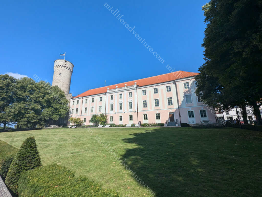
Halifax is the capital and most populous city (about half a million) of the Canadian province of Nova Scotia. The native name Kjipuktuk (che-book-took) means “Great Harbour” in the native Mi’kmaq language. It owes its existence to its location as it sits on one of the largest and deepest ice-free natural harbours in the world.
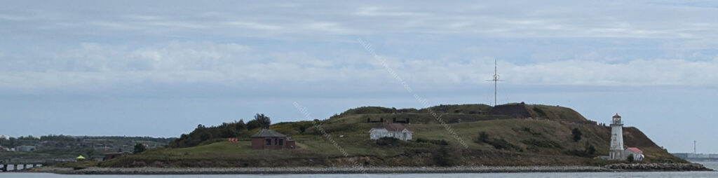
Our ship pulled into the docks with the town on the right and Georges Island on the left. Georges Island is the home of Fort Charlotte, an old fortification with a maze of brick tunnels that once housed the ammunition for the fort’s powerful guns in bomb-proof security.
The right hand side featured one of the best developed port and dock facilities that we have experienced so far. This place has truly developed to maximise its harbourside and centralise the tourism. The wide boardwalk and infrastructure that has been built on the harbourfront really makes it a tourist friendly environment.
The waterfront is several kilometers long, with cafe’s, shops, restaurants, breweries and bars lining almost every step of the way. The boardwalk has statues, parks, swings, historical markers, and educational signposts all the way along. Some places do their ports well, but this place was a step above.
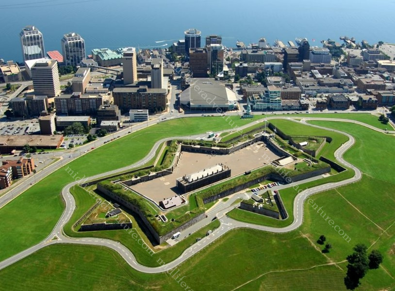
The city itself is dominated by the hilltop Citadel, a star-shaped fort completed in the 1850’s. Four fortifications have been constructed on Citadel Hill since the city was founded by the English in 1749
All but the third iteration have been called the Halifax Citadel. The last part built is a concrete star fort. While never attacked, the Citadel has long been the keystone to defence of Halifax Harbour.
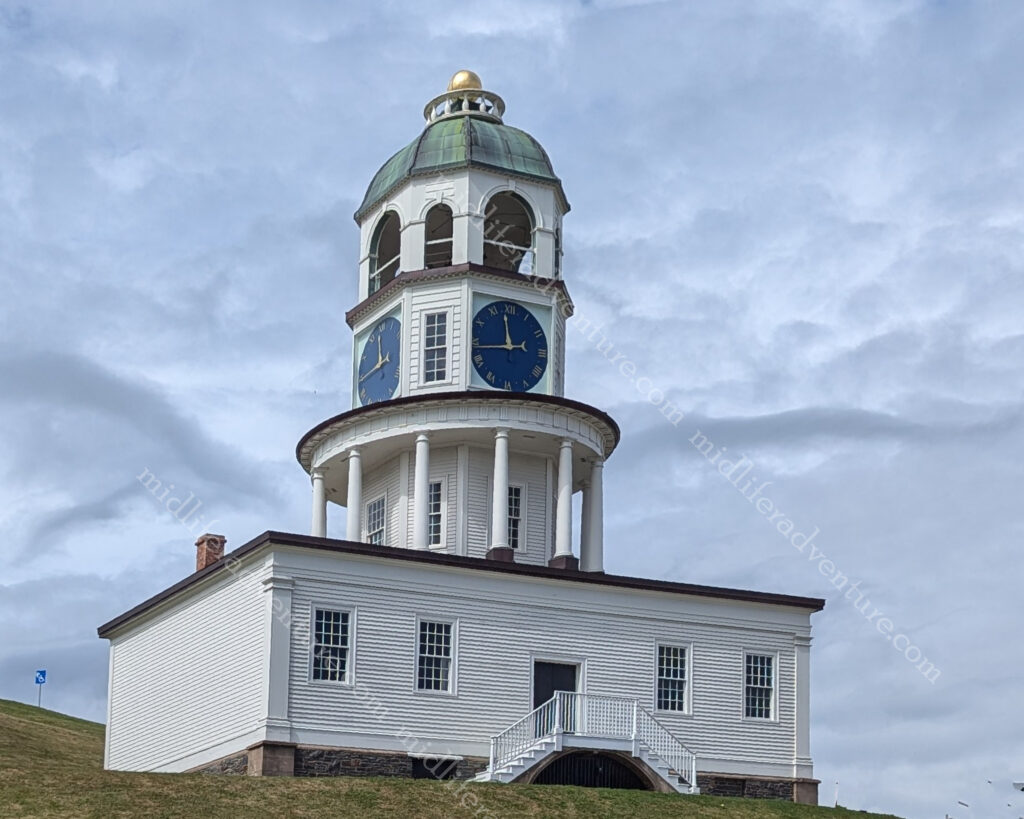
At the approach to the Citadel you find the Town Clock (sometimes called the Citadel Clock Tower). It is a three-tiered octagonal tower built in 1803 on a box, originally facing the barracks. It is four-sided so that soldiers had no excuse for tardiness.
With over 13,000 kilometers of coastline, Nova Scotia offers an abundance of seaside entertainment options. Most notably it is known for its lobster and seafood.
Nova Scotia has some of the most fertile lobster fishing grounds on the planet. It has become the lifeblood of many working fishing communities in Nova Scotia as they hunt for the Atlantic Lobster. The tourism board has developed the Lobster Trail which is a collection of lobster restaurants and diners around Nova Scotia. On offer along the trail include traditional lobster dinners, chowders and rolls. Then there are some rather odd offerings like lobster poutine, lobster tacos, and lobster mac & cheese.
Along with the Lobster trail, Nova Scotia also has a Good Cheer Trail. This trail celebrates the abundance of wineries, breweries, cideries, distilleries and meaderies that are throughout the province. The Good Cheer Trail celebrates all five of these craft beverages.
Along with the waterfront, the rest of the town has a nice collection of Street Art. Interesting murals abound and almost every corner reveals something new or surprising.
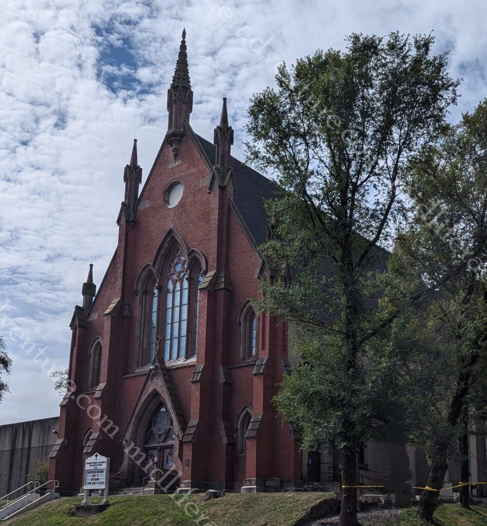
The Presbyterian Church of Nova Scotia, was founded in 1817 but did not have its permanent home in Halifax until it took over the old Methodist church and established the Church of Saint David.
Originally built in 1868-69 the Church overlooks and is surrounded by the old Methodist burial ground.
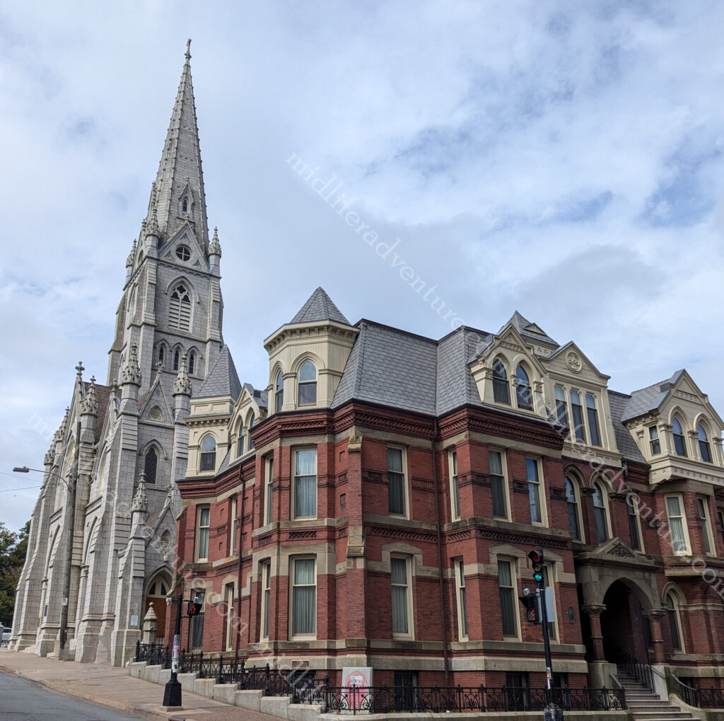
Saint Mary’s Cathedral Basilica is a Gothic Revival Catholic cathedral in downtown Halifax.
Pope John II visited the cathedral back in 1984 to commemorate the 200th anniversary of the Cathedral.
With thousands of kilometers of coastline, it’s no surprise Nova Scotia has the largest number of lighthouses of all of the Canadian provinces. There are more than 150 dotting the coastline. Lighthouses are a common sight along the coasts and remain an important symbol of the past, and highlight the coastal landscapes. Some lighthouses are open to the public with guided tours, while others can be accessed from short trails and hikes.
The town is small with not that much going on, but everything that there is is on full display and is easily accessible. I am not entirely sure that I have ever been in a city or town with as many pubs, restaurants and bars. It seems like every block has at least 5 bars on it. This doesn’t sound like a lot, but as you walk block after block the numbers really add up.
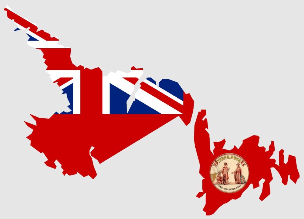
Newfoundland and Labrador is a province on the far east of Canada. The island, was named by late 15th-century explorers as the New Found Land.
It has an area of 405,000 sq/km and a population just over half a million and is often called the “seabird capital of North America”. Being on the ocean, Newfoundland has extensive access to marine wildlife with whale watching (from boats or the shore) all year round. The peak of this is July and August (when we were there).
The water off Newfoundland is the perfect place to spot humpback whales, which can grow to almost 16 meters long. Along with the humpbacks there are 22 species of whales that visit Newfoundland at some point during the year. Travel websites consistently rate it as one of the world’s friendliest places.
St. John’s
Our entry was into the capital, largest city of the region and one of the oldest cities in North America St Johns. It sits on the eastern tip of the Avalon Peninsula on the island of Newfoundland and is most easterly city in North America.
The city is located on a man made harbour protected on one side by Signal Hill and on the other side of the narrows Fort Amherst (a lighthouse with the remains of gun emplacements built during World War II to defend against German U-boats).
The town/city has been inhabited since 1497 with a permanent settlement for most of the 16th century. A city of São João in this location was placed on a Portuguese map from 1519.
Our entry saw us wandering along the esplanade to the Newman Wine Vaults the region’s only publicly accessible historic wine cellar. A really great historical tour through the cellars for very little money.
One of the best reasons to visit Newfoundland is to get up close to the giant icebergs that float down from the Arctic Circle each year. Even from far away, their sheer size is unbelievable. As we had just come from the Greenland fjords and Prince Christian Sound we had pretty much had our fill of icebergs over the preceding days.
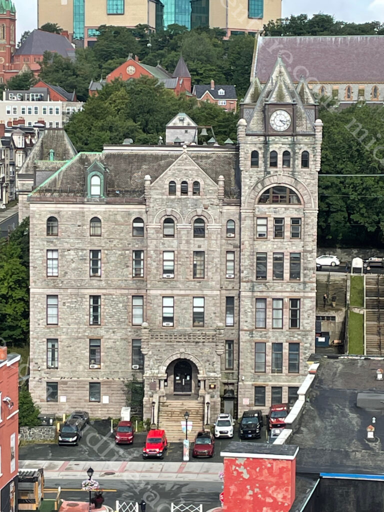
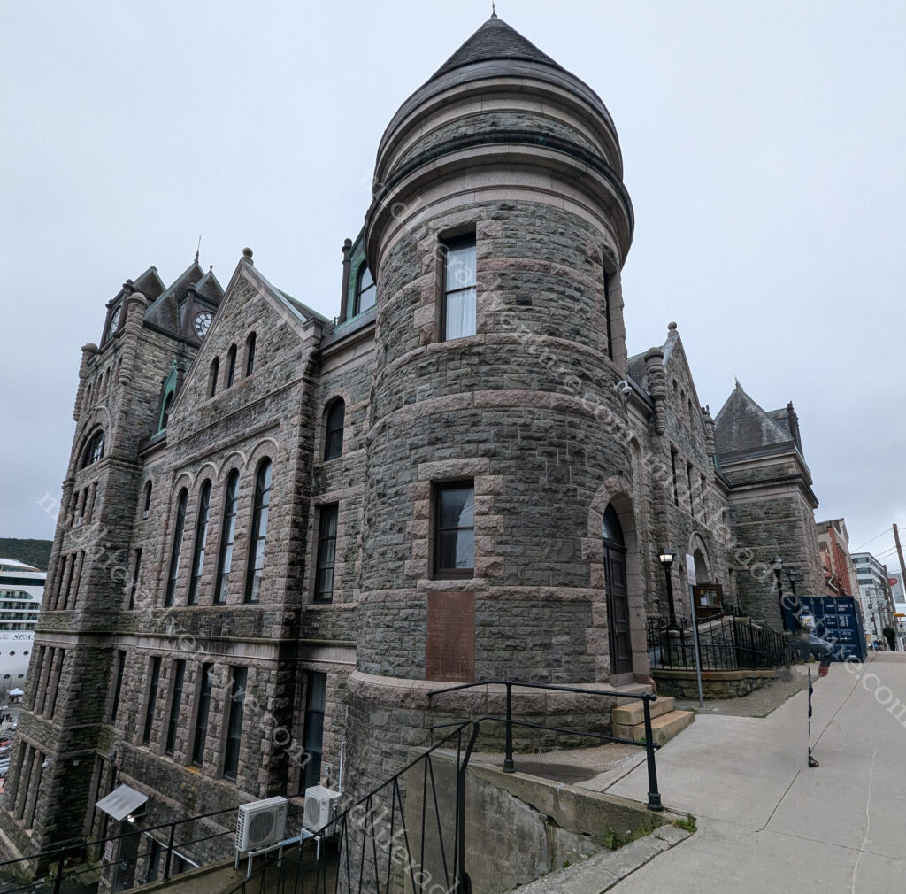
Our first view of the city saw us staring at what we thought was a Cathedral, but on closer inspection, turned out to be the Supreme Court Building.
The St. John’s Court House is located on Water Street and Duckworth Street.
Constructed in 1901–04, the building is a National Historic Site of Canada.
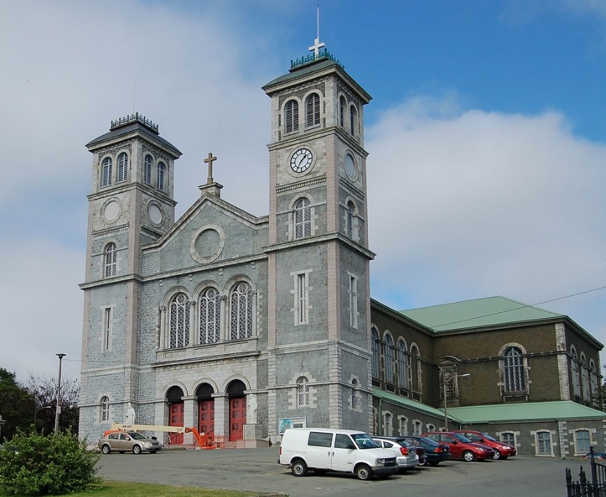
The Basilica-Cathedral of St. John the Baptist is the Cathedral of the Roman Catholic church.
Construction started through excavation in 1839, laying of the cornerstone in 1841, until completion and consecration in 1855.
For such a cold and chilly location, St Johns has a real bent towards outdoor eating and drinking. All along the main (water) street there were tables and decks taking over the roadway for alfresco dining.
As seems to be the way every time we visit Canada, there is an abundance of homelessness and begging. This started in Vancouver, but continued here and seems to be commonplace throughout Canada. But here they didn’t even try to claim it was for food, they were overtly asking for money for weed and alcohol.
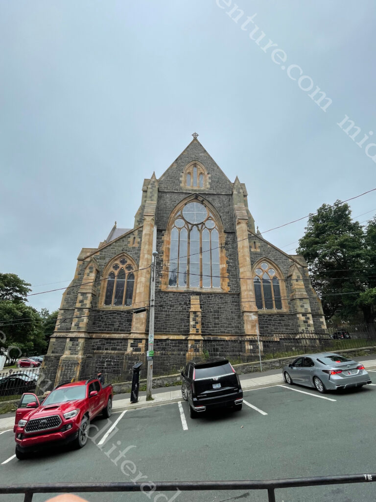
The Cathedral of St. John the Baptist is the Anglican cathedral located in the city of St. John’s.
The Anglican parish was founded in 1699.
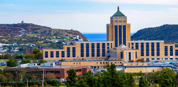
The Confederation building is a historic government building that was the home of the colonial and later provincial Newfoundland governments, and the House of Assembly.
The war memorial was simple but really well executed and a pleasant place to stop and reflect, while you walked your way around town.
Newfoundlanders are a very warm bunch and before long, we found ourselves chatting away to some locals and getting a sense of the colourful row houses that abound. According to legend local sailors had trouble distinguishing their houses in times of fog (alcoholic or literal) so they elected to paint their homes in bright colours to make them more visible.
Getting screeched in
To become an honorary Newfoundlander one must get screeched in. This involves a tradition (borne out of the bars on George Street) who will happily do it for a fee. To get screeched in, one must listen to the barkeep’s spiel, in response to the question “Is ye an honorary Newfoundlander?” recite the phrase (“Deed I is me ol’ cock, and long may your big jib draw!”), drink a shot of screech (a type of cheap rum), kiss a cod on the mouth (Jill’s one was named Seamus), and chase it down with a small slab of bologna.
The term Screech used to be used for any type of moonshine, but is now marketed as rum, consumed with great pride by locals, and honorary locals alike. It allegedly got its name due to the sound you make after consuming it (back when the alcohol content was not controlled and was highly variable).
This is something that Jill did and as an honorary local was then obliged to settle in and have a few more drinks with the locals. Our ship was due to depart at 4:30 pm but rumours abounded that due to weather we would stay overnight and not leave until the next morning. So we headed back to the ship, confirmed the extension of our time in port, dressed more warmly, and headed out again to hang with Jill’s newly adopted people.
We found a few more places to visit and I had my first ever moose burger, to go with the musk ox burger I had eaten a few days earlier.
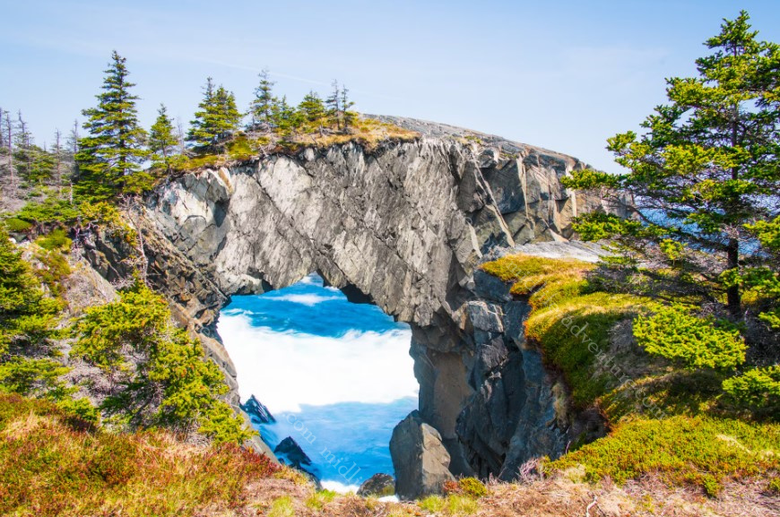
Berry Head Arch is located half way along (12.4 km) in to the east coast trail, a nature walk south of St Johns.
Needless to say we did not do this.
There are more than 8,000 shipwrecks in and around Newfoundland with dozens of them in Conception Bay, near the capital. So if you are into scuba diving and can bear the water temperatures (not me) there is a heap to be seen.
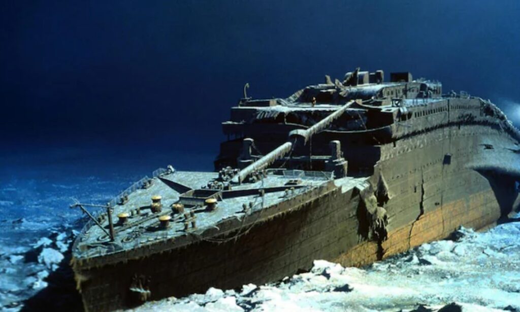
Our journey to Newfoundland took us very close to the final resting place of the Titanic. According to the National Oceanic and Atmospheric Administration the Titanic sank about 400 miles off the coast and the wreckage remains about 350 miles from Newfoundland.
In one of the many exploration and salvage attempts of the Titanic, an Irish team was amazed to report that after all of this time that the swimming pools of the Titanic were still full.
Ok so two of my closest mates (Jimmy and Angelo) had both spent the preceding week and month respectively in Sweden and both raved about how good it was.
My mate Angelo has been coming for years and catching up with some local friends and Jimmy was catching up with family.
So Sweden got quite the buildup before we had even arrived therefore our expectations were high.
At 450,295 square kilometres and a population of a bit over 10.6 million, Sweden is the largest Nordic country and the fifth-largest country in Europe. Sweden has been inhabited since prehistoric times, c. 12,000 BC. A unified Swedish state was established during the 10th century and in 1397, Sweden joined Norway and Denmark to form the Scandinavian Kalmar Union.
The Swedish Viking Age lasted from the eighth to the eleventh century with Swedish Vikings travelling east and south, going to Finland, Estonia, the Baltic countries, Russia, Belarus and Ukraine. Stockholm is the capital and Gothenburg is the home of Volvo.
Stockholm
The city of Stockholm is situated on fourteen islands and on the banks of the archipelago where Lake Mälaren meets the Baltic Sea.
Our entry to Sweden was on an overnight ferry (more like a cruise ship) from Finland. This meant that we sailed in past some of the 267,570 islands that Sweden has to offer.
This made for a pretty spectacular way to enter a country.
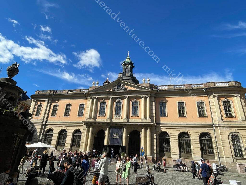
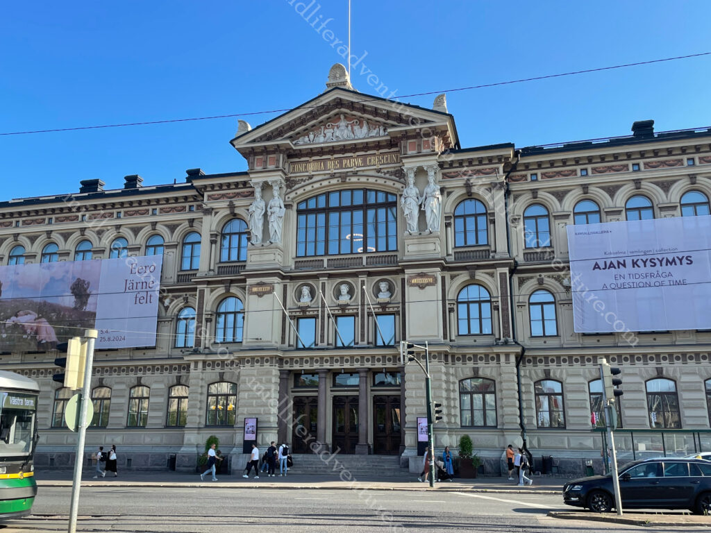
After landing we grabbed a car from the docks to our hotel, which was quite literally right next door to the central railway station (we would leave by train). Once settled we headed straight for a flea market that we had passed on the drive in. As it turned out, the market was being held in the square in front of the Stockholm concert house (Konserthuset) which was built after WWI. Since 1926, the Nobel Prize in medicine, physics, chemistry and literature has been awarded (on 10 December each year) in this concert hall.
The flea market was more flea than market, so we took some happy snaps and continued our journey. This saw us getting to Sergels torg a public square with a sunken pedestrian plaza and a distinctive grey and white triangular design. As we tend to do, we were wandering in the general direction of the palace but got distracted by funky looking buildings. The first that we saw was Saint Jacob’s Church.
Around the corner and we were in the Kungstradgarden, a long and impressive greenspace linking the city heart to the water.
The Kungliga Opera House that is home to the Royal Swedish Opera and the ballet company. As seems to be the way, the entire side facing the water was covered in scaffolding. But as in Helsinki, they did leave the front relatively clear.
As you cross the bridge you find yourself on a tiny little island and a park called the Riksplan, a public park with the Swedish Parliament house (Riksdagshuset) on your right.
And directly across from that is Gamla stan, the old part of the city that holds important things like the Royal Palace and Museums (Kungliga Slottet). We arrived at about 1pm to see hundreds of people starting to mass at the gates. A snappy google search told us that the changing of the guard would take place at quarter past. We started to hang about, but about three tour bus loads later and we decided to walk away.
Storkyrkan Cathedral is the oldest church in Stockholm and lies in the centre of Gamla stan, between the Palace and Stortorget, (the old main square of Stockholm).
It was built in the 13th century and currently serves as the seat of the Bishop of Stockholm.
Also on the Gamla Stan Island you will find the Nobel Prize Museum, a small museum with vast content.
Just across from Gamla Stan is another small island that is home to the Riddarholmen, the church of the former medieval Greyfriars Monastery. It is the largest church in Sweden and serves as the final resting place of most Swedish monarchs. We have seen quite the number of churches over the years, this one is up there with the best.
With Jimmy having just left Sweden, he talked up a couple of beverages that he rated particularly highly. So based on his recommendation we headed to a venue, ordered his suggestions, and then tinkered with some others. Fair enough to say that they were not terrible and we slowly sipped our way through the afternoon.
Having blitzed the old town area all that was really left was to wander the streets and check out the mix between old and new that Stockholm has to offer. It was pretty similar to Helsinki, but somehow felt so much more interesting. I cannot explain why but the feel here in Stockholm was much more welcoming.
Gothenburg
Gothenburg is the second-largest city in Sweden, with a population of about 600,000 and 1.1 million in the broader metro area. The city isn’t actually called Gothenburg, in Swedish the city is named Göteborg, roughly pronounced yaw-ta-bore(g). Founded in 1621 it quickly became a major commercial fishing and shipbuilding hub, and later the birthplace of Volvo.
It sits on the west coast of Sweden and has been ranked as the world’s most sustainable city for the last six years running. Gothenburg was the first city in the world to issue green bonds to stimulate investment in solutions to climate change. Almost all the city’s hotels are eco-certified and plans to develop a zero-emissions transport zone in the downtown district are well underway.
Jönköping is located on the highway between Stockholm and Gothenburg. The tourist blurb suggests that there is plenty to do around Jönköping. This includes things like the lake Vättern Biosphere Reserve, fishing, camping, hiking/biking trails, kayaking, and of course there is the safety match museum.
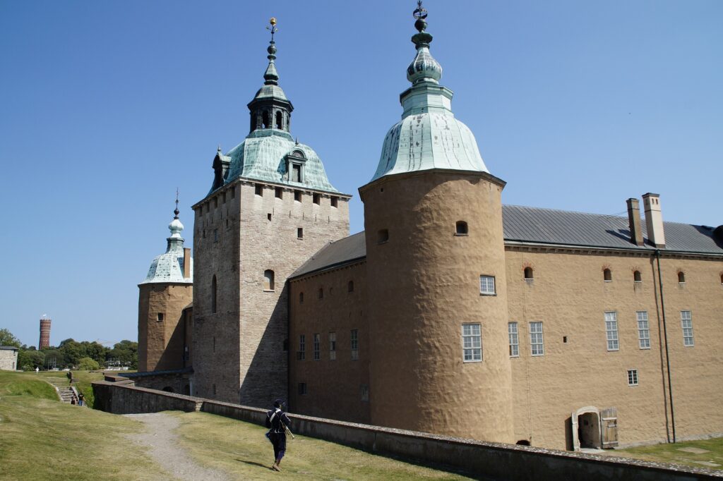
Kalmar is by the Baltic Sea near the Danish border and is surrounded by water. It was a fortified city and a stronghold for royal power (13th to the 17th centuries). At the center is the Kalmar castle, which was used to defend Sweden against invasions.
Älmhult is the home of Ikea. It is a city/town of about 9,000 and it houses both the Ikea Hotel and the museum. The museum is massive and showcases the design and history of Ikea. while the hotel is the only place you can stay in a room completely furnished with 100% Ikea products. They even have price tags and information about where to find them in the store!
The most important thing that we learned in all of out time in Sweden, is that Australians pronounce the most famous Swedish store (Ikea) incorrectly.
We typically call it (eye kee ah) but after much consultation we have learned that it is actually pronounced (ick ee ah).
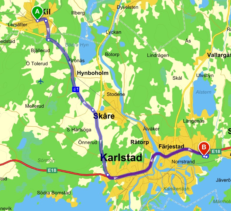
Leaving Sweden ended up being quite the adventure, it wasn’t meant to be it just happened that way. Our day started at about 5am with a short (about 100m) walk to the central train station where we waited and boarded our fast train towards Oslo in Norway. All went swimmingly for the first couple of hours with some stunning Swedish countryside to be taken in.
Until the train ground to a halt in the town of Valsviken. Apparently there was an issue at the next stop (Karlstad) which meant that no train (from either direction) could enter. This meant that we all got kicked off the train and milled about at the wrong station waiting for buses to come and get us to drive us to the station that they couldn’t use.
Once at the broken station we then got ferried to the next town of Kil where we met up with the similar train going in the opposite direction. Apparently they had all been similarly dumped and bused and were wending their way to the train that we had just abandoned.
While it all seems fairly innocuous, the communication throughout was less than stellar and there was much milling about in the cold and the wind while confusion reigned supreme. Hundreds of people, not enough buses, poor communication and at least 7 languages in play made for an entertaining few hour delay and drama.
On the up side, we got to see even more of the amazing Swedish countryside and lakes. The place really is very pretty.
Sweden had a really nice feel to it. By all accounts, the real value of Sweden is not to be found in town but in nature. There are countless national parks and nature reserves in Sweden along with four biosphere reserves. A Biosphere reserves is an ecosystem of special scientific and natural interest that are left undisturbed. In addition to this there are the many rivers and lakes that we drove past that are visually just stunning. So I guess we have a reason to return.
The area that is now Finland was settled around 8,500 BC during the Stone Age towards the end of the last glacial period. The artefacts the first settlers left behind present characteristics that are shared with those found in Estonia, Russia, and Norway.
Finland covers an area of 338,145 square kilometres (130,559 sq mi)[4] and has a population of 5.6 million.
In 1906, Finland became the first European state to grant universal suffrage, and the first in the world to give all adult citizens the right to run for public office.
The nation remained a largely agricultural country until the 1950s. After World War II, it industrialised quickly and established an advanced economy. It became a member of the EU in 1995, the Eurozone in 1999, and NATO in 2023.
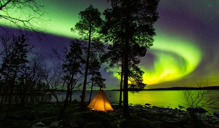
Finland in the summer months – the sun doesn’t set at all in the northernmost parts of the country, hence the nickname “The Land of the Midnight Sun.” In the winter, the opposite happens, and the sun disappears for months. This time is called “kaamos”.
And – if you’re lucky – the Autumn and Spring may bring the colourful Northern Lights (photo from visitfinland.com).
And according to the WHO (World Health Organisation) Finland has the best air quality in the world.
Getting here
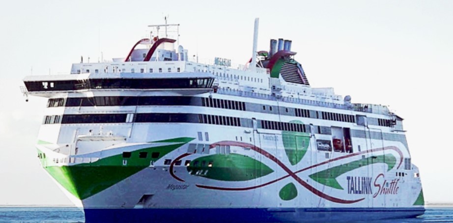
Our trip to Finland from Estonia was on the ferry. I must be honest and say that the idea of a ferry was not all that appealing. But on arrival I was met by more of a cruise ship than a ferry. The modern European ferries make the Australian ferry options look absolutely prehistoric. Our trip was on the Tallink Megastar.
The Megastar is the newest ship in the Tallink fleet and has been operating since 2017. The 212 metre vessel can hold 2800 passengers and reach speeds of 27 knots.
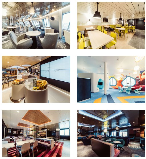
It has restaurants, bars, the largest mall on the Baltic Sea and a 2,800 square meter Superstore (think Myers) that is a fully stocked.
Add to this a huge duty free shop where you can get spirits, wines, beer, cigarettes, sweets, cosmetics and perfumes.
The garage area has a capacity of 150 vehicles.
The ride only took 2 hours and there was quite literally not a wave to be seen. The Baltic Sea (at least when we were there) was a millpond. Long story short, my fears of the ferry were unfounded and in reality this is the best and most relaxing way possible to get around up here.
Helsinki
Helsinki is the capital of Finland with a population a bit over 600 thousand. I will state right now that the beer and the local food was absolutely the lowlight of our time here in Finland. Both the price and the taste left us both unimpressed. We did find a Syrian restaurant that saved us, but the local fare on offer was not great.
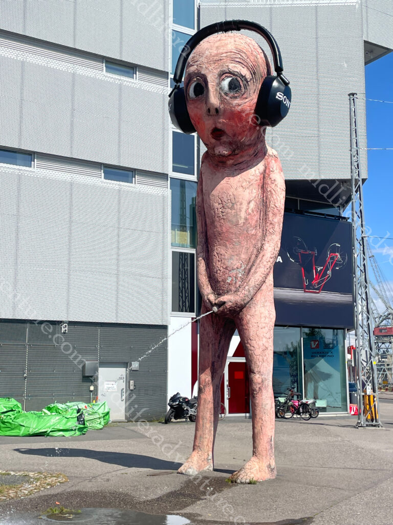
Our introduction to Helsinki was when we left the port and walked about a kilometer away to get our Bolt car without the harassment of the local cab drivers. Here is where we found the Bad Boy. It is a pink 8.5 metre sculpture made of concrete that weighs in at about seven and a half tons. And it is of a boy pissing. The water flow in the sculpture is heated so the boy can urinate all year round, even in winter.
It was was originally ordered as part of a public art festival in Sweden, where it urinated into a river in a park.
It then moved to Market Square in Helsinki where it urinated into the ocean in front of the Presidential Palace.
It most recently moved to in front of an electronics store, where it acquired a set of headphones.
There is a HOHO bus in Helsinki, but it is €34 each, and the town centre and loop really isn’t that big and is easily walkable. The Mannerheimintie is the central avenue that runs through the heart of the capital. Unlike the old towns of the Baltics, Helsinki is a very modern city.
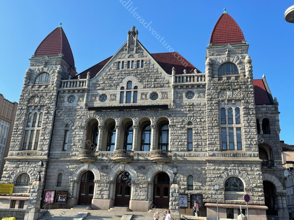
But we were here and it was time to explore. Our wander towards town saw us looking at some interesting looking buildings, nice parks on a cool and pleasant day in the heart of town. Once we got to the circular Swedish Theatre we were in the heart of it.
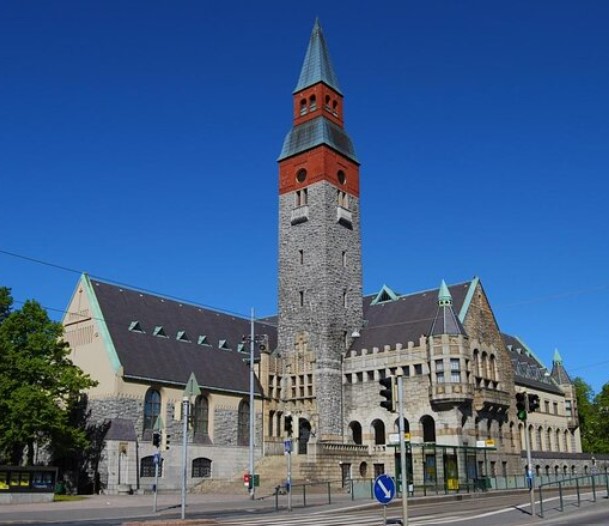
Modern blocks, full of rows of shops and shopping malls to rival any modern city on the planet. There was the odd glimpse towards something vaguely historical, but for the most part it was just a modern city. The central railway station signalled the start of a bit more character. The railway tracks were built in the 1860s an the granite clad station in 1919. The building is known for its clock tower and the Lyhdynkantajat (“The Lantern Bearers”).
Just down the road from the train station you come across Rautatientori square and the the Finnish National Theatre. founded in 1872, is the oldest Finnish-language professional theatre in the country.
Across the road you find the Ateneum, which is the major Art museum in Helsinki. It is one of the three museums that forms the Finnish National Gallery.
The National Museum was closed for renovation at the time we were here. But when it is open it looks like this and it traces the Finnish history from the Stone Age to the present.
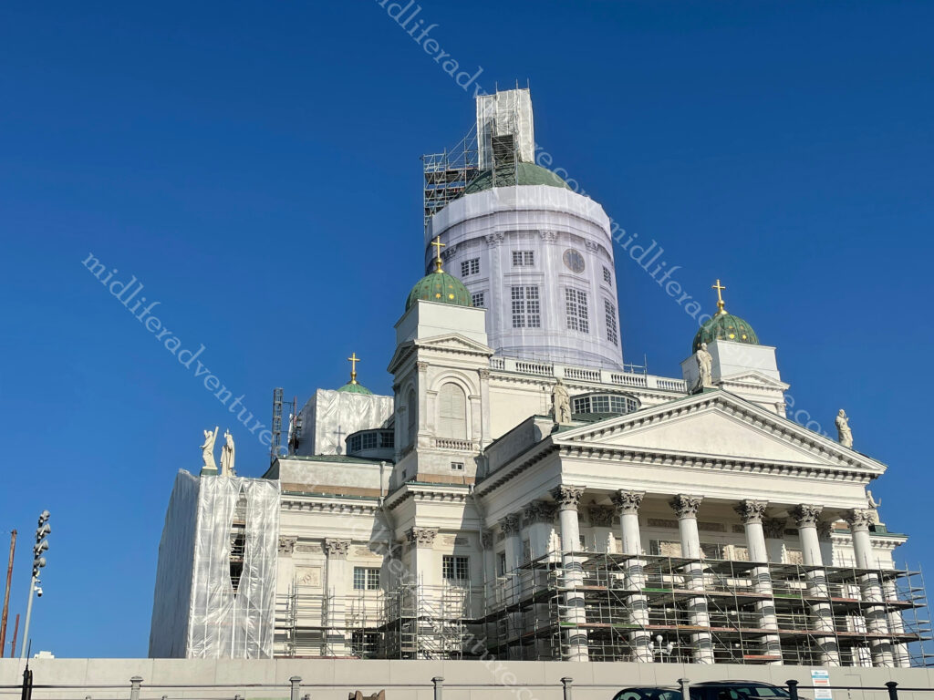
Helsinki Cathedral was one of the must do major attractions and once again, it was under construction.
The usually stunning building was covered in scaffolding.
While the main building was under renovation, they did leave one side free for photographs. Added to this the Cathedral sits on Senate Square, which is impressive enough in its own right. The square is in the oldest part of central Helsinki and is ringed by the Cathedral, the Government Palace, the main building of the University of Helsinki and the oldest building of central Helsinki (Sederholm House dating from 1757).
Having had enough for day one and walking plenty we made our way back towards our accommodation, stopping for some very poor local beers and bites on the way. The next morning a great breakfast primed us for another day of walking to explore the rest of the city. But first we headed down to the location of the open air flea market. This was clearly just a weekend thing, and after standing and scratching out heads for a while it was back to the Mannerheimintie.
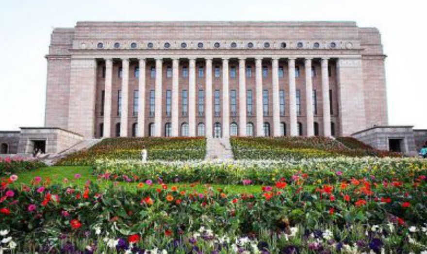
Also on Mannerheimintie you will find the Parliament house which was designed and built after WWI.
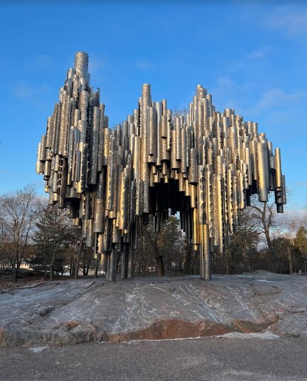
The Sibelius Monument is a park sculpture dedicated to the Finnish composer Jean Sibelius (1865–1957). It controversially looks like organ pipes, despite the composer not making music for the organ.
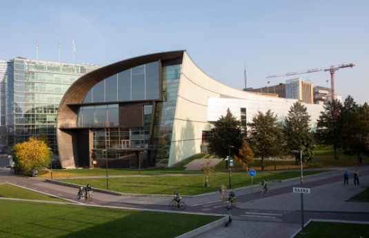
Kiasmais is a very funky location and is the home of the contemporary art museum.
At the end of the Mannerheimintie you run into the waterfront and the usual tourist fare that goes with that. A bunch of local ferries come and go, and there is a huge number of (summertime) pop up stalls to feed them and extract some money for trinkets. Add to this a Ferris wheel and a swimming pool and the place is complete.
Up the hill from the waterfront you will find the highly impressive Uspenski Cathedral. This is the largest Orthodox church in western Europe and is visited by half a million people annually. The cathedral’s size is emphasized by its location on the highest hill of the Katajanokka district. The central cupola of the cathedral is 33 meters high. The cathedral was designed by a Russian architect and was consecrated in 1868.
Suomenlinna sea fortress is a Unesco World Heritage Site located on the coast of Helsinki. It is accessible by ferry and is also a suburb of Helsinki with around 800 residents. The fortress was shaped by three historic eras when it helped to defend first Sweden, then Russia and ultimately Finland. There are six kilometres of walls, 100 cannons, exciting tunnels, and beautiful parks.
In the past, all of Finland’s houses were built of wood and usually painted red, with a few blue and yellow thrown in.
Some of these have been preserved and sit just as they did decades or centuries ago. Visiting these picturesque places is like entering a living time capsule. Within Helsinki the districts of Käpylä (about 8km north) and Vallila (about 5km northeast) will give you an opportunity to explore some of these.
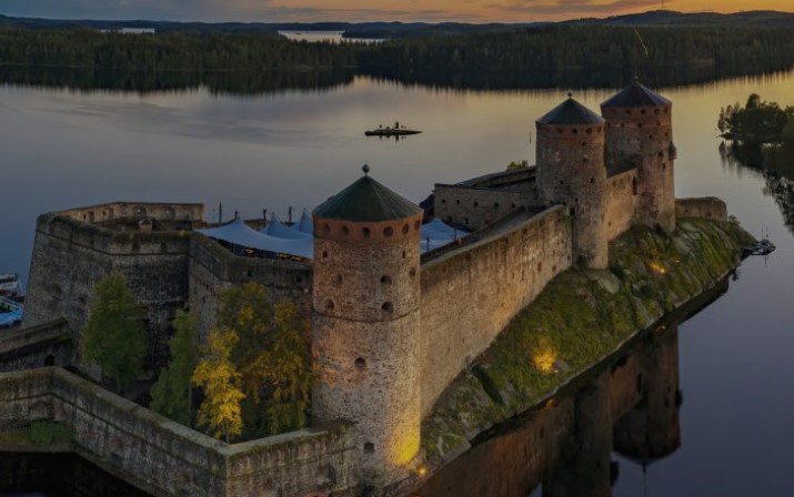
Olavinlinna Castle (also known as St. Olaf’s Castle) is one of Finland’s best known tourist sites. It was founded in 1475 and is built on an island in the Kyrönsalmi strait.
At around 400km from Helsinki we didn’t get here but it did look pretty cool. Our time in Helsinki was mixed. The town initially did not impress, but it did grow on us the more we explored. The local food and drink options were both expensive and poor, but other options (non-Finnish) were readily available and were typically better priced.
While it was perfectly nice, I don’t see either of us rushing back to Finland anytime soon. The weather was nice, the people friendly but this ticks one of those been there-done that type boxes rather than the oh my god we have to go back.
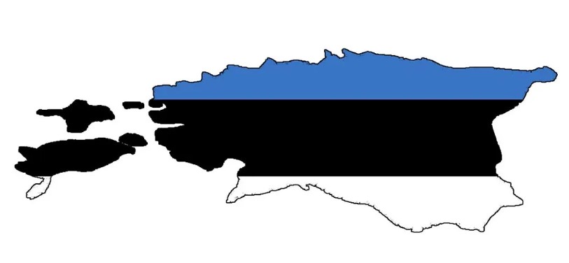
Estonia finds itself at the edge of the European Union, connecting Europe to Russia, combining the best of the Nordics and the Baltics.
Estonia consists of the mainland, two larger islands (Saaremaa and Hiiumaa), and over 2,300 other islands and islets on the east coast of the Baltic Sea. The area has been inhabited by humans since at least 9,000 BCE. The Estonian mainland was one of the last pagan civilisations in Europe to adopt Christianity (after the crusades in the 13th century).
Once again my early knowledge was limited but the writeups suggested that it was as good as Latvia and Lithuania but with a much prettier Old Town. Given that we loved the old towns of the other two, then this was something to look forward to.
The train to get us here from Riga for some unknown reason was to take us around 12 hours, but the local 5 star bus only took three. So the bus it was. A very calm and relaxed bus ride, with full WIFI all the way. A cab ride (bolt actually) to the hotel and we were ready to explore the Old Town of Tallinn.
Tallinn
Tallinn is the capital city of Estonia, with a population of a little under half a million. The town sits on a bay on the shore of the Gulf of Finland of the Baltic Sea. The oldest evidence of habitation dates back 5000 years with evidence of hunting and fishing settlements.
As an important port on a major trade route between Novgorod (northern Russia) and western Europe in around 1050 AD, a fortress was built on the hill of Toompea in what is now central Tallinn.
The Church of St. Nicholas is one of the oldest in the city, dedicated to the patron of the fishermen and sailors.
It was partially destroyed in the Soviet bombing of Tallinn in WWII. While the building has been restored, it has not been used for regular religious activities since WWII. It now houses the Niguliste Museum.
Our accommodation was just outside the old town (closer to the port, as that would be our exit) but still a short walk to the centre of things. It retains its walled, cobblestoned Old Town which is now home to cafes and shops. Our entry saw us wander down to the town where we were met with some amazingly thick brick walls that made up the medieval defences.
At this point we entered and were already impressed. We passed through the gates and found ourselves on cobblestoned streets staring at old buildings and church spires. Almost every corner you turned landed you onto a new scene with old buildings, museums, churches, medieval defences, you name it.
The wandering continued until we found ourselves in the heart of old town at the Town Hall Square. This has been a marketplace and the centre of town since the Middle Ages and became the centre of Old Town in the 13th and 14th centuries.T he central part of the square is the gothic Town Hall that was built in the 13th century with its 64m-high tower.
In summer the square is packed with restaurants and at times plays host to medieval festivals, and is also a venue for open-air concerts, and fairs. In winter it becomes a Christmas market, the centrepiece of which is a towering spruce tree. The tradition of celebrating Christmas festivities here dates back to 1441 when the Brotherhood of the Blackheads are thought to have erected the world’s very first Christmas tree.
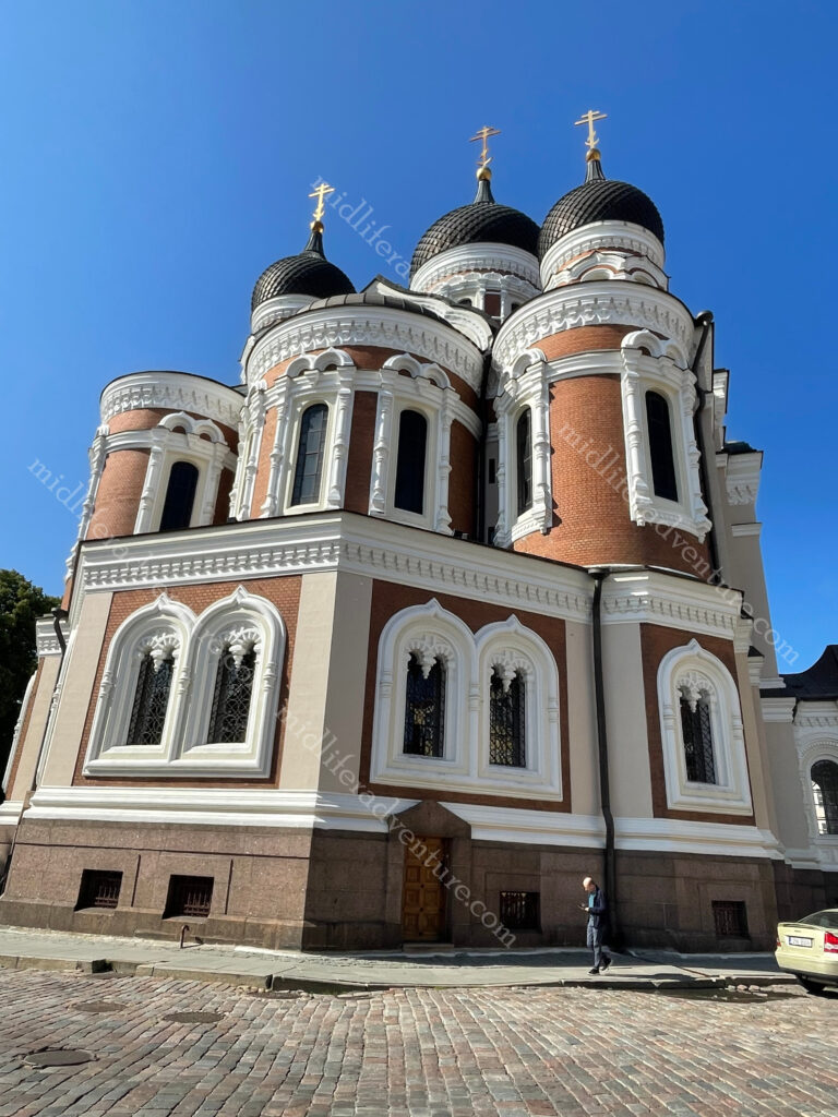
Alexander Nevsky Cathedral is an Eastern Orthodox Church. It was built in 1894–1900, when the country was part of the former Russian Empire.
The cathedral is the city’s largest cupola church.
Up at the top of the hill near the cathedral you will find another defensive tower known as Tall Hermann and the old Toompea Castle.
As you keep coming down the hill you run into the Kiek in de Kok .
Meaning peep into the kitchen in old German and Bastion Passages Museum is a 15th-century defensive tower.
It is an artillery tower built in 1475 and is 38 m tall, has walls 4 m thick and still has Cannon balls dating back to 1577 embedded in its walls.
And as a 55 year old man I really should be more mature than to still find the name amusing.
Coming down the hill from the Kiek in de Kok you find yourself entering Freedom Square, at the southern end of Old Town. Freedom Square holds a Victory Column (2009) commemorating the Estonian War of Independence 1918–1920. The square also abuts St. John’s Church (built 1862–67).
And all around the outside of the Old Town is patches of the old city walls and the renovated gates that take you in and out.
We really enjoyed our time in Estonia, and in fact all three of the Baltic nations. The food has been good, and with one exception so have the beverages. Temperatures in February are terrible but by the time summer rolls around you are pulling low to mid 20’s with long days, so there is plenty of time to explore.
Our August foray into the three Baltic nations was pretty much spot on. It is technically the high season with the most tourists, but the volume of tourists coming here is way less than you will get in places like France or Italy. So even at peak times, the place is really manageable.
Lithuania is a developed country with a high income, advanced economy, ranking 37th in the Human Development Index (HDI) and 19th in the World Happiness Report (Australia is ranked 10 on both).
To be honest, I knew almost nothing about Lithuania before arriving here. We hopped a train from Poland and made our way to the Lithuanian capital of Vilnius. The city lies in the southeastern part of the country at the confluence of the Neres and Vilnius rivers.
Lithuanians , Poles , Jews and Belarusians have historically considered Vilnius as their cultural center. A university has been operating in Vilnius since 1579.
Legend of the Iron Wolf
According to the legend, centuries ago Grand Duke Gediminas, was on a hunting trip in the forests of Šventaragis valley around the mouth of the River Vilnia. When night fell, the party, feeling tired after a long and successful hunt, decided to set up camp and spend the night there. While he was asleep, Gediminas had an unusual dream in which he saw an iron wolf at the top of the mountain standing with its head raised proudly towards the moon, howling as loud as a hundred wolves.
The Duke remembered his dream and consulted the pagan priest about it. He was told that the dream was a direction to found a city among the hills.
The howling of the wolf represented the fame of the future city: that city will be the capital of Lithuanian lands, and its reputation would spread far and wide, as far as the howling of the mysterious wolf…’ So the Grand Duke Gediminas, obeying the will of gods, immediately started to build the future capital which took the name of Vilnius – from the stream of the rapid River Vilnia.
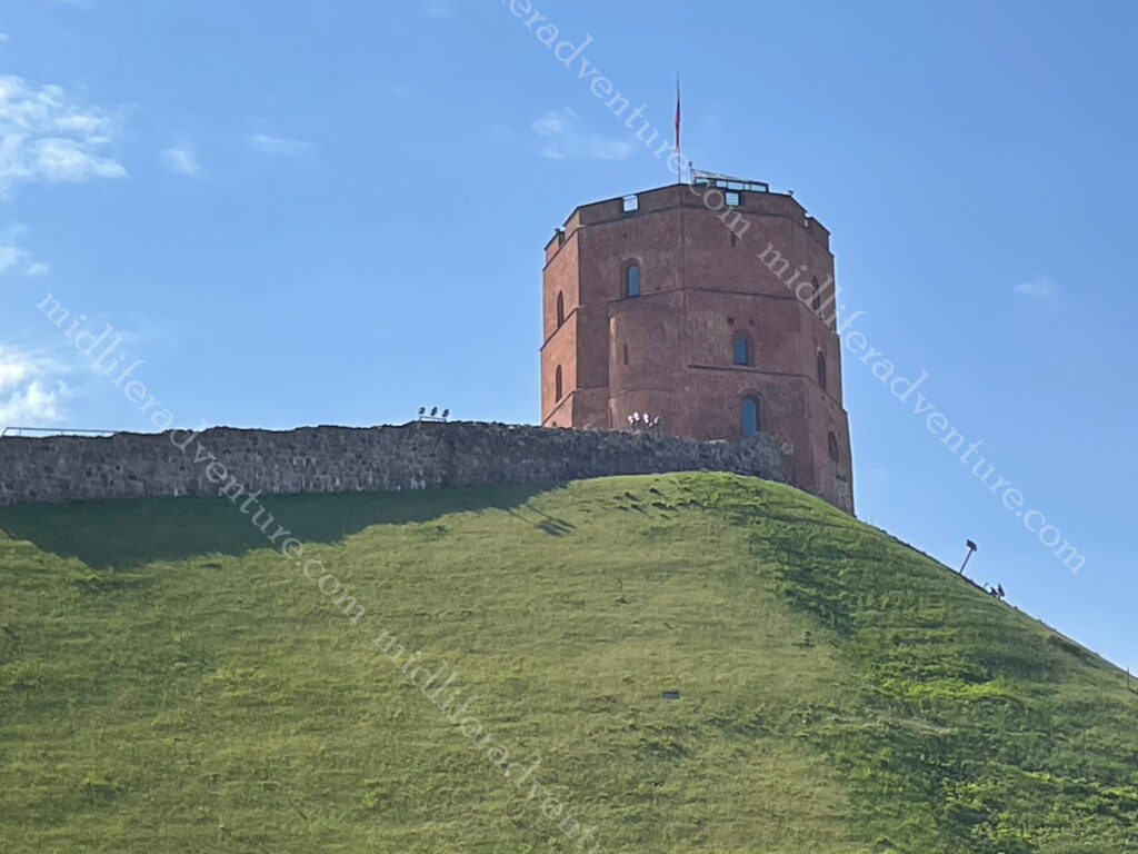
He built a fortress on the hill (Gediminas Tower) and the city of Vilnius grew up around it. You can still climb the hill and visit the Tower which provides one of the best views of this beautiful city. We however chose to pay 3 euros and use the funicular.
Hopping off the train we found ourselves in one of the cleanest and most cared for cities we have ever seen. This place was Japanese level clean and well tended for, certainly cleaner than anywhere we have ever been in Australia. Our hotel was a charming little joint, about 700m from the train station and right on the fringes of Old Town.
The oldest buildings in Vilnius were built in the 13th century. The main attraction is absolutely the Cathedral Square. It is not only the most important location in the city, but is also one of the most significant and widely known symbols of Lithuania.The square regularly hosts events such as: fairs and gatherings of townspeople, military parades, religious and official public events, attractions and large concerts, New Year’s salutes and exhibitions.
The main feature of the square is the Cathedral Basilica of St Stanislaus and St Ladislaus of Vilnius. The square was so important that it was the main feature on the 50 litas banknote (pre-euro), the layout included.
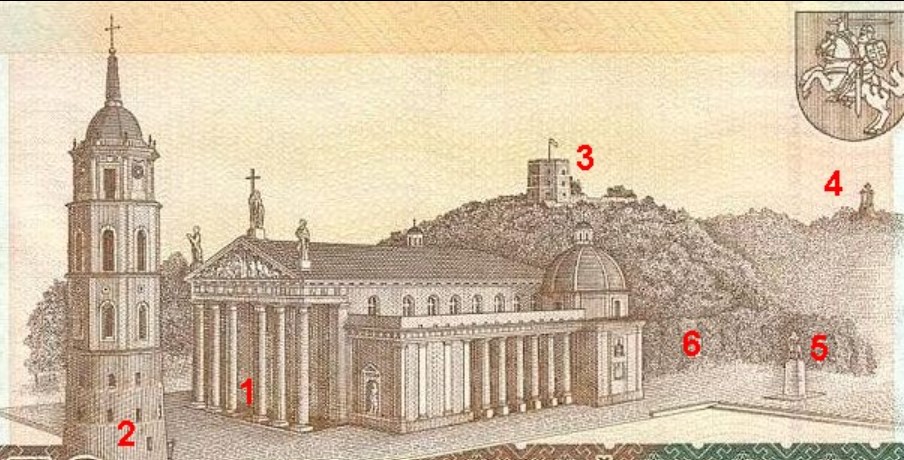
1. Vilnius Cathedral 2. Cathedral’s Belfry 3. Gediminas Tower 4. Hill of Three Crosses 5. Monument to Gediminas 6. Royal Palace
The Valdnieku (Grand Dukes) Palace , next to the Cathedral has been converted to house the history museum. Up the hill was Gediminas Castle Tower, which we took the funicular to reach the top. From here we got panoramic views over the city and surrounds.
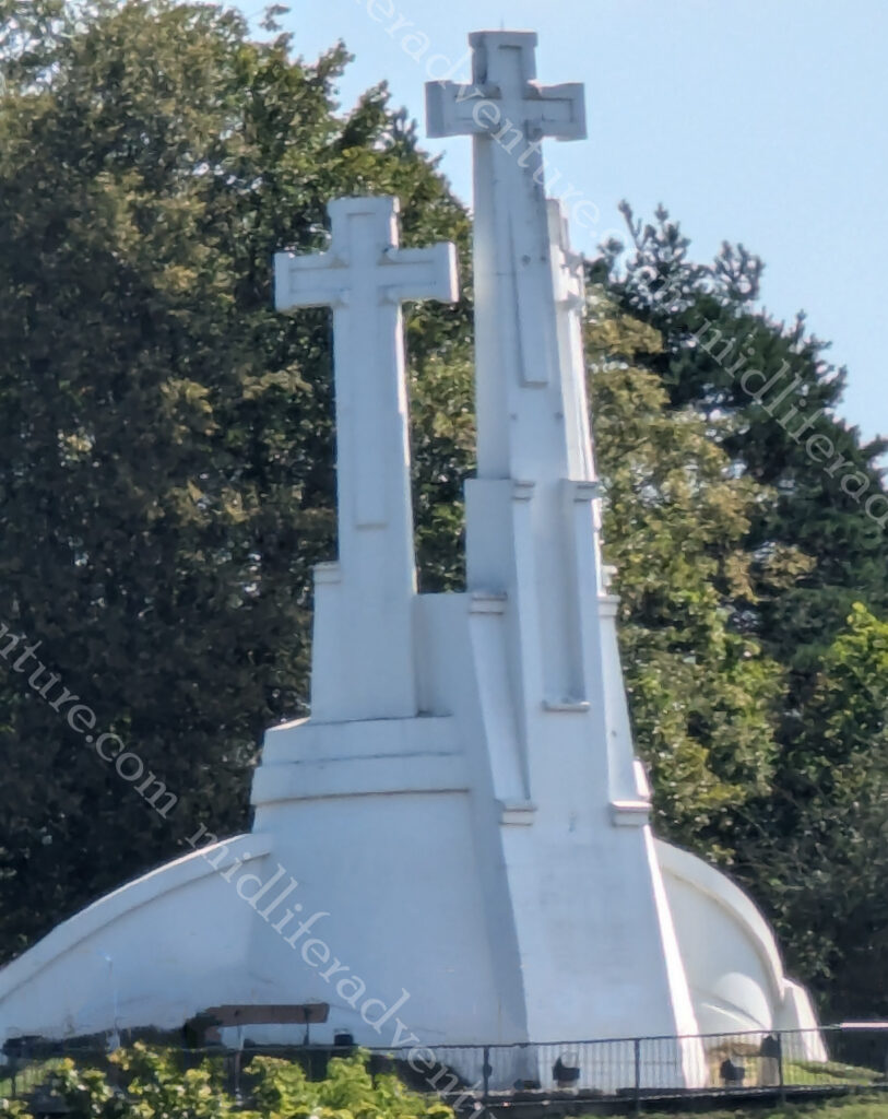
The Three Crosses memorial consists of three white reinforced concrete crosses.
The hill got its name after Franciscans died as martyrs when pagans tied them to crosses and threw them down the hill. The three crosses were erected to commemorate this event.
At the bottom of the hill and the far (back) end of the Cathedral you find yourself in the Bernadine Gardens. We did the slow meander through here on our way to St. Anne’s Church. By this time the masses of tourists had crawled out of bed and were making seeing the sights unpleasant.
In an attempt to dodge some crowds for a while we found ourselves in a local cafe/bar where Jill found her long awaited steak tartare. She had been wanting one of these since Prague, but for a variety of reasons was unable to have one up until now. So that with some zeppelins (potato/meat dumplings) washed down with an Argentinian specialty (Aperol and fresh orange juice) and a local lager.
The sheer volume of beautiful old buildings and churches to be seen in and around Vilnius is astounding. And they are all (and I mean all) in perfect condition. There is no scaffolding, no graffiti, no shoddy paint. There is a real pride to the standard of the buildings, everywhere you look.
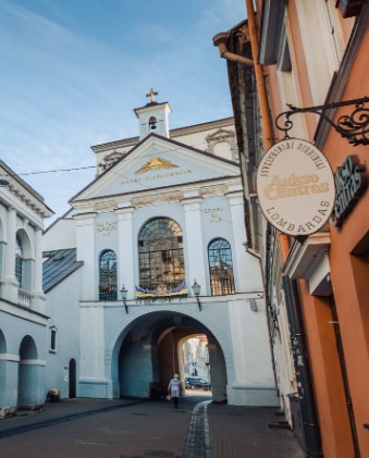
The Gate of Dawn, or Sharp Gate is a city gate that was built between 1503 and 1522 as a part of defensive fortifications for the city.
City gates often contained religious artifacts intended to guard the city from attacks and to bless travelers. The Chapel in the Gate of Dawn contains an icon of The Blessed Virgin Mary, Mother of Mercy, said to have miraculous powers.
Upon arrival we went hunting (online) about places to eat in the general vicinity of where we were. This is a common search for us on arrival in a town. The magic search phrases are restaurant near me, cheap eats near me, local food near me. We were surprised to find that the results trickled in rather than overwhelmed us.
Not finding anything that rang our bells, we decided to just wander about and see what we could see. What we found was an abundance of places to eat, but they were pop-up restaurants for the summer season. Not permanent fixtures but rather just places that took over open spaces and became an alfresco dining heaven.
The food was good, the prices were reasonable (maybe even cheap) and the setting was stunning. Warm (mid 20’s) summer evenings, cool beverages and great food offerings. This gave us some flashbacks of Spain and the way we lived back then.
To sum it all up, Lithuania was fantastic. We did not spend enough time here and will definitely put it on a list of places to come back to. August really is a spectacular time of year to visit here.
Tunisia is the northernmost country in Africa with a population of a little over 12 million. It is bordered by Algeria (west), Libya (southeast) and the Mediterranean Sea to the north and east. It also shares maritime borders with Italy and Malta.
Like most of the nations around the Mediterranean it has a long and potted history about who controlled the area that is now Tunisia. And this recorded history starts with the Berbers before the 12th century BC. In 146 BC the Romans defeated the city of Carthage and had control of the place for the next 800 odd years. In the 7th century AD, Arab Muslims had their turn and conquered Tunisia, moving in in huge numbers over the next few hundred years. In 1546, the Ottoman Empire took control for the next 300 years, until 1881, when the French conquered Tunisia. In 1956, Tunisia finally gained independence as the Tunisian Republic.
Tunisia has odd currency laws and will confiscate cash if you get them wrong.
Most countries allow you in and out of the country with the equivalent of USD $10,000 and more so long as you declare it.
But not here.
Here you are allowed to bring in 10,000 dinar (about $3300 USD) and
must declare amounts over 5000 dinar.
It is a criminal offence to export Tunisian dinar
so make sure you change everything back before you leave
any unchanged dinar will be confiscated
Anything over the 5000 dinar (equivalent) will be confiscated
about USD $1500 or 1300 euros
We found this out the hard way when I got my bag deconstructed by the agent (on the way out of the country) looking for cash. In essence, if I had any Dinar left over or more than about USD 1500 or 1300 euros in cash on me, they were within their rights to confiscate it from me. There are grounds to get it back if you get a receipt and return to the country within 3 months. However, nobody who had tried this (based on online commentary) could locate where the money could be collected from due to Bureaucratic runaround.
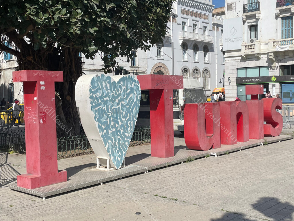
Tunis
Tunis is the largest and capital city of Tunisia with about 2.7 million residents in the greater Tunis area.
And is a great place to kick back and chill.
The biggest surprise for me was the cab drivers. As any regular traveller knows, cab drivers in almost every nation are as sketchy as hell and are always trying to rip you off. Yes, there are some exceptions, but for the most part, we have stopped using taxis (even in Australia) in favour of ride-share apps.
But that was not the case here. The cabs all used meters, without being asked, were reasonably priced and did not try and tout and prey upon unsuspecting tourists. A refreshing and pleasant change.
The TunisMedina is (apparently) the best preserved in all of North Africa. It is the historical and cultural heart of the city, with buildings dating from the 18th and 19th centuries. It is home to the souks, the markets, workshops and ateliers. Allegedly there is a pecking order to such things and therefore they are arranged hierarchically around the Great Mosque.
The souk is nowhere near the bedlam that was Marrakesh, but there is still plenty going on. And the available artisan work is of the highest quality. It is cleaner, quieter, has less touts and is generally much more manageable for the shy tourists.
The Jamaa ez-Zitouna mosque, or ‘olive mosque’, is the oldest in the city. It was founded at the end of the 7th century or in the early 8th century, but its current architectural form dates from a reconstruction in the 9th century. The mosque is said to be one of the most important in all of Islam and covers 5,000 square metres, with nine entrances. The building includes many antique columns reused after the destruction of Carthage. Due to the nearness of the souk in the Medina, you only really get to see some columns and arches.
Being non-Muslims, we typically just admire the outside of mosques and rarely enter. In many cases, we are not allowed in anyway, but even when we are we tend not to. Some of the rooftops around the Medina offer amazing panorama views over the Medina, and some even stay open for after dark shots.
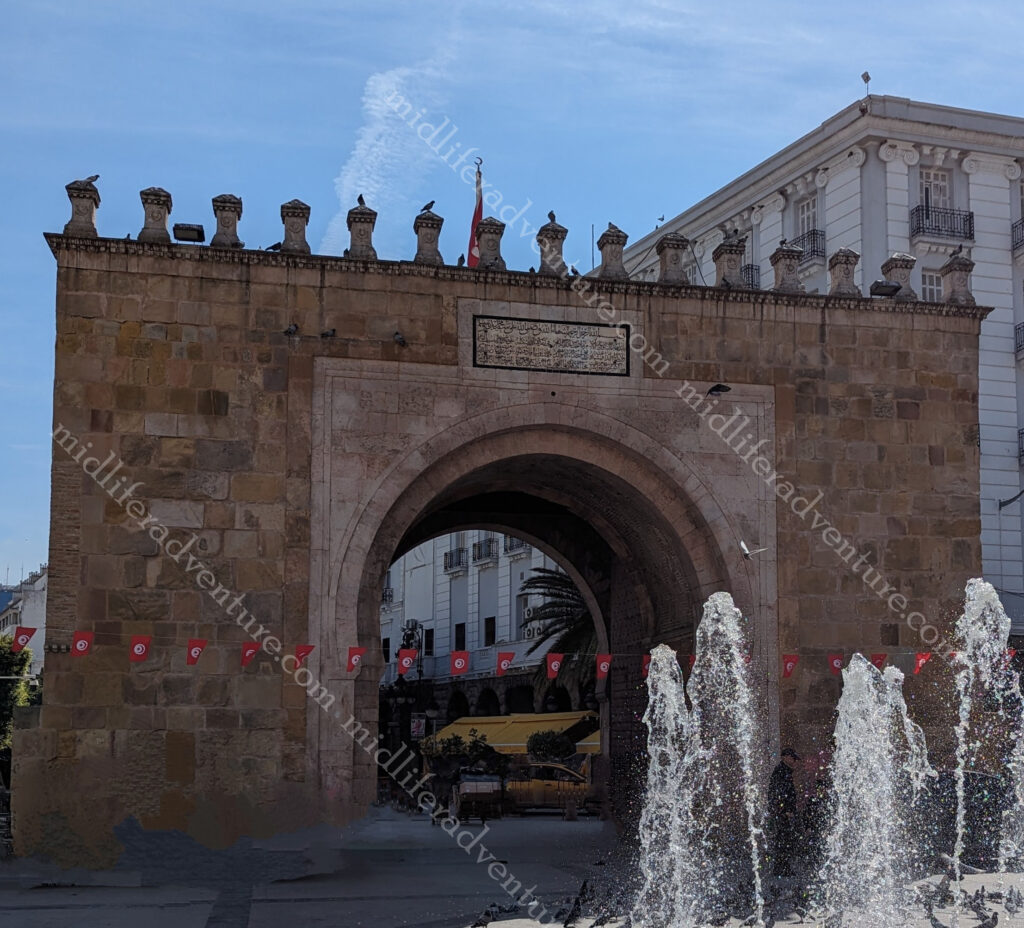
The Sea Gate (also known as the Bab el Bhar and the Porte de France) is the entrance to the Medina from the new part of town.
New Tunis
East of the Medina, is the modern part of the city called “Ville Nouvelle”. This area is often referred to by media and travel guides as “the Tunisian Champs-Élysées. It is a grand avenue lined with colonial-era buildings.
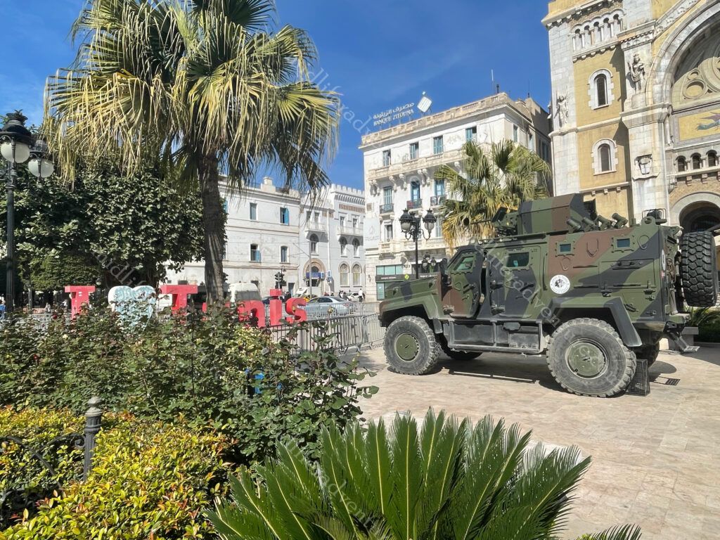
While Tunisia has had its share of security issues over the decades, at no point did we feel unsafe or uneasy. There was an off-putting security presence in the new town area that seemed extremely over the top for what was going on. Armoured vehicles, heavily armed military and blockades were everywhere and there was nothing going on.
A more timid day I had never seen, clear blue skies and almost nobody on the streets, but the grand avenue had a visibly present and unnecessarily confrontational security presence.
Doors
For some strange reason I found myself taking photos of the doors (especially in the Media) of Tunis. They were truly stunning. Some huge and ornate, while others simple but there was something about the doors in this place that just grabbed me.
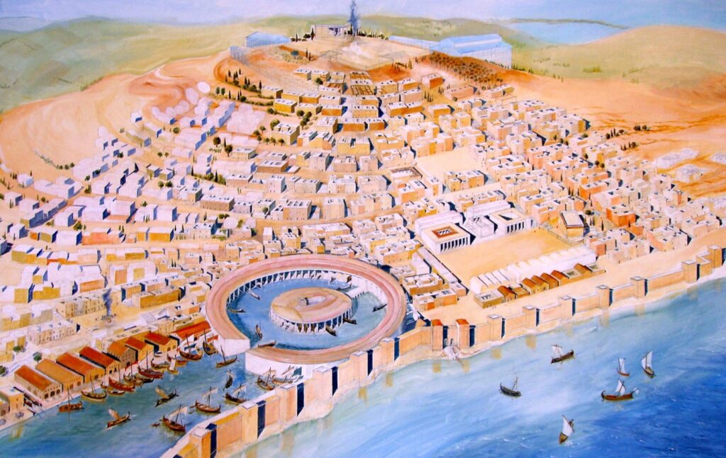
Carthage was a city I had heard mentioned in documentaries and the like, but never really knew where it was or much about is. As it turns out it is here on hte outskirts of Tunis and was one of the most important trading hubs of the Ancient Mediterranean and one of the richest cities of the classical world.
It has a history dating back to the 12th century BC. and between 650 BC to 146 BC, it was the most powerful trading and commercial city in the Mediterranean.
It had a sophisticated 200-dock circular harbor and the funds earned prompted investment in a sprawling metropolis of temples, markets, and estates.
And all of this is just a 20-minute drive outside modern day Tunis. It was quite the sight until 146 BC when the Romans came an lay siege to the place for 3 years.
Today there are 7 main sites that are left to see in Carthage and one ticket ($6 each) will get you into all the sites. The place is about 15-20 km out of town (a $7-8 cab ride) and our (flash) hotel was charging exorbitant rates for their tour (over $150 a head). So we hopped a cab and headed to the ruins.
But be warned the 7 places are a fair distance between each other. We made the mistake of thinking it was like the Roman Forum and was within an easy strolling distance. We got dropped off at the archaeological site and found ourselves stranded.
So we hiked about 1.5km to the Cathedral remains (Saint Cyprien) that were both shut and quite unimpressive. And then another 1.7km walk up to the roman houses and villas. The lady at the gate at the villas entry was busy talking on her phone. So Jill stood in front of her and waited, and waited and put her money on the counter and waited. After quite literally 12 minutes of this, she picked up her money, turned around and walked away. With some choice words.
Unsurprisingly, as soon as she took her money and turned away the girl got off the phone and was ready to serve Jill. Some more choice words and we continued to walk away from her, with some more choice words. About 500m further on we found ourselves at the Roman Amphitheatre where we paid our entry and entered with no issues whatsoever. And across the road was some more ruins.
Another 1.5km walk and we found ourselves atop Byrsa hill at the Saint Louis Cathedral and the acropolis of Byrsa. This is the site of the Carthage Museum and an impressive number of pieces of Roman Columns and the odd statue.
About 2km down the hill was the last of the sights (given that we boycotted the Roman Villas due to the attitude of the girl on the counter) the aqueducts. Built in the 2nd century BC by the emperor Hadrian, they brought water more than 100kms from Zaghouan to Carthage.
Ramadan
For some reason, Jill has taken to booking us into Muslim countries during Ramadan. Last year it was the Maldives and this year it was Morocco and Tunisia and later in Istanbul. This is a forced alcohol detox as the nations typically do not serve alcohol anyway and during the holy month there is no chance.
The other thing it means is that almost every restaurant is closed and by the time the sun goes down, you tend to be a bit peckish. Thankfully we found a little joint that served brilliant local dishes for a song. Our (flash) hotel was offering a set (abridged) menu for 100 dinar ($50) a head, so we hit the streets hunting for better. And did we find it.
A little hole-in-the-wall joint, with a huge upstairs terrace, great food and entertainment for 45 dinars ($22.50) a head. Dinner was salad (more dips really) and bread, traditional soup, and the main (that came cooked and served in a weird shaped pot) was a hearty stew type thing. We went looking the next night for something different but ended up at the same joint and had a seafood main and some form of crispy egg crepe in place of the soup.
We had planned a trip to Dougga, which is lauded as “the best-preserved Roman small town in North Africa”. But I guess this will sit high on the list of things to do next time we come.
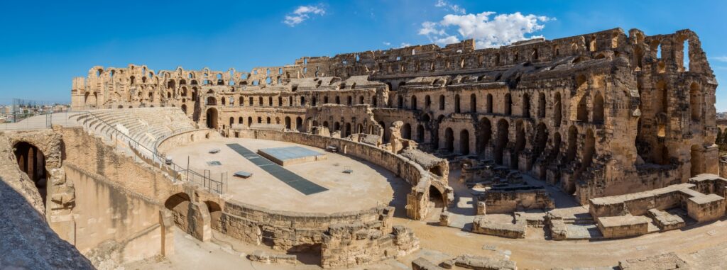
The Amphitheatre of El Jem is an amphitheatre in original town of Thysdrus although now known as El Djem. It was built for the usual roman spectator sports (gladiators etc) around 238 AD and is one of the best preserved stone in the world. It was one of the biggest amphitheatres in the world with an estimated capacity of around 35,000.
And sadly, this is one of the many things that we did not get to. So this (along with a bunch of other reasons) rates as a pretty good reason to come back.
Tunisia was great and there was so much more for us to see and do. It was a great pity that the currency issue as you leave puts a bad taste in your mouth. Other than this we really enjoyed our time here and will be back.
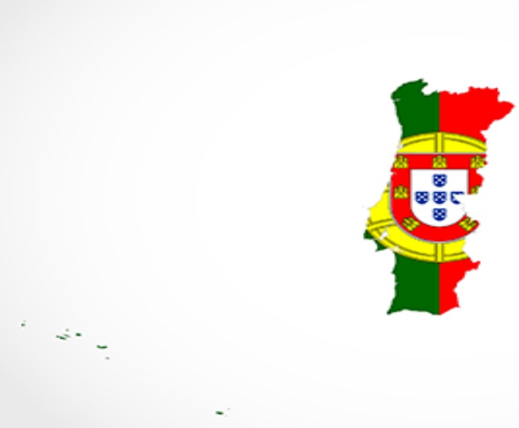
Portugal is the westernmost country of continental Europe and includes the island groups of the Azores and Madeira (both autonomous regions in the north Atlantic Ocean.
It has existed as a country since the 12th century (originally as a monarchy) but has evidence of civilisation dating back beyond 10,000BC. The nation was integral in the discovery and exploration of Africa and South America.
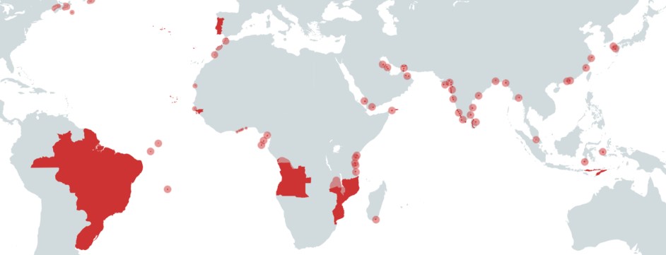
The Portuguese empire differed from the Spanish empire because the Spanish conquered large areas of land while the Portuguese preferred to control only major trading ports. Throughout the 15th century, Portuguese explorers sailed the coast of Africa, establishing trading posts for commodities, ranging from gold to slavery.
The Portuguese empire created colonies in Africa including Angola, Mozambique, Guinea. Added to this was the islands of the Azores, Madeira, Cape Verde Islands (off the coast of Mauritania-Senegal), and Sao Tome and Principe (islands in the Gulf of Guinea). Then there were the major ports of Cochin, Goa (in India), Colombo (Sri Lanka), Macao (China) and Nagasaki (Japan) in East Asia and of course Brazil.
Lisbon
OK, so we have been to Europe about 6+ times now and this was our first foray into Portugal. How stupid are we? This place is fantastic. We got off the plane and grabbed (a really cheap) Uber to our hotel. The driver was the nicest and most helpful person we had ever met, to the point where we both commented on it. Until the next day when we got our next Uber to the Monastery when the same thing happened, and then again on the way back.
These people are just super friendly and want to ensure that everyone who visits enjoys their time. Add to this that the pricing is more than reasonable for everything and the sights have a nice mix of natural beauty and old world charm how can you go wrong here.
We were not really blessed with the weather here, it rained for two and a half of our three days here. We got the odd glimpses of sunshine (particularly on day one) and in between there were some some pretty soggy days. Our day two was on and off sunny with the skies changing every 10 minutes or so until it finally settled in.
Our hotel was perched high on the hilltop in oldtown, which sadly had been built on the side of a damn mountain. As beautiful as the views were, it meant that everywhere we went was either up, or down, a ridiculously steep hill.
Finding your way around the old town could not be simpler, just follow the tram tracks. Be sure not to be run over by cars, trams, tuk tuks, bicycles, vans etc, that are all competing for the narrow road, but just follow along and you will pass pretty much everything that there is to see.
The tram goes past almost all of the tourist spots in the old town and centres around the main square, Praca do Comercio. This will include the churches, palace, castle, bars, cafes and restaurants. As long as you can see the tracks, you will see the bits.
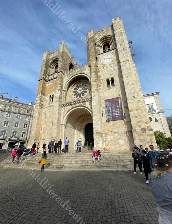
Jammed in the middle of the tracks you will find Sé de Lisbon. This cathedral started being built in 1147 and ended in the first decades of the 13th century.
The tram tracks quite literally split and run either side of the triangular street entrance.
Castelo de S. Jorge Stands on Lisbon’s highest hill and offers panoramic views of the city. The fort dates back to Moorish times (11th century), and has served as military barracks and royal chambers. Currently, it functions as a national monument, museum and archaeological site, with fantastic views and great gardens. And if this is off season, I hate to see the lines in peak times.
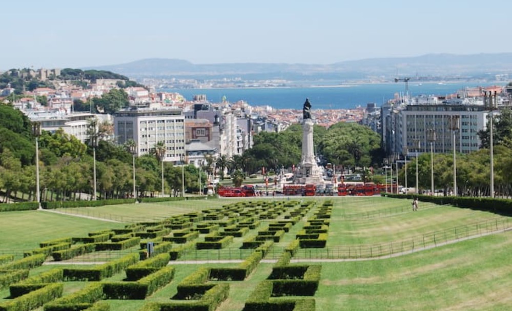
Lisbon’s central park is named Edward VII Park taking up 26 hectares in the middle of town. It was named as a tribute to the British Monarch.
Mosteiro dos Jeronimos (Jerónimos or Hieronymites Monastery) was originally donated to the Order of the Friars of St. Jerome. Construction began in near the launch point of Vasco da Gama’s first journey. Its construction lasted for a hundred years and was funded by a tax on the profits of the yearly Portuguese India Armadas. The day of our visit the weather kept coming and going, alternating between blue skies and torrential downpours.
To say this place is impressive is a massive understatement. Everywhere you look is a different aspect of the place and the intricately carved windows and openings act to frame the next amazing sight.
Portuguese Custard Tarts (Pasteis de nata)
Lets not be silly we have all eaten these. Whether it is the cheap boxed up ones in Costco, or the ones after a Chinese Yum Cha (bearing in mind that Shanghai was one of the Portuguese territories), or just from some dodgy bakery that does them. And they are always good, even the shitty ones are great, with their signature flaky crust and sweet custard filling they are world-famous, and incredibly delicious.
But now we are at their point of origin, and sadly, all others pale by comparison to the original version. It was created by monks at the Jerónimos Monastery and has certified origin. The original recipe is called Pastel de Belém and we found our way to Pasteis de Belem which is right next to the monastery and is recognised as their true home. And in case you were wondering, they were good.
Literally across the road from the Monastery is a park and the Discoveries Monument which serves as a monument to Portugal’s Age of Discovery on both land and sea.
The monument was reconstructed in 1960 to mark 500 years since the death of the Infante Dom Henrique (Henry the Navigator).
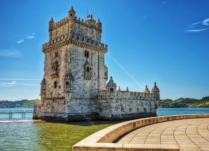
A few hundred meters down the bank of the Tagus River you find yourself at Torre de Belém. This is a 16th-century tower that is a mix between a medieval keep tower and a modern bastion. It was built to guard the river entrance into Lisbon’s harbour.
That evening we found our way down to Praca do Comercio which is one of the biggest squares in Europe, this stylish area in downtown Lisbon often displays beautiful works of art and sculpture and is a great place for a leisurely stroll.
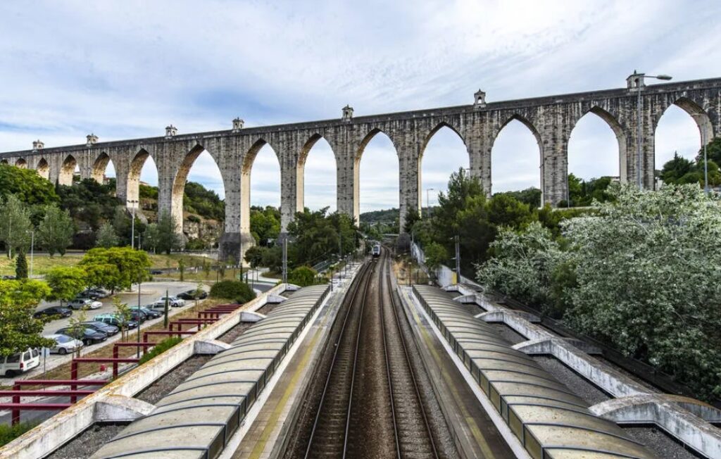
The Aqueduto das Águas was built in the 18th century to supply water to the town. Its construction was funded by special levies on meat, olive oil and wine. It stretches 14 kilometres and can now be visited as a tourist attraction.
The blurb for the Museu Nacional do Azulejo said that it was a must-see for people interested in the history and design of ceramic tiles. Now lets be serious here, that is not a title that I have particularly aspired to. But being in Lisbon, you do get a fair old appreciation of the ceramic tile as almost every building is finished (on the outside) with them. Looking at the photos of the museum, if it is your thing, then this specialty museum does house an impressive collection of decorative tiles dating from the 15th century to now.
The Coaches Museum is one of Lisbon’s most visited attractions, and is a collection of fairytale type carriages that have been used by the royalty and nobility of Europe over the centuries. While most European royal carriages were destroyed over time (especially in Paris after the French Revolution), in Portugal they were preserved. Most of them date to the 17th to 19th centuries, but the oldest example dates back to the late 1500s.
Brazilian BBQ – Portuguese Style
On our third Uber ride, our driver asked us if we liked seafood, which of course we do. He then went on to tell us that in Portugal, they do a similar thing to the Brazilian BBQ but instead of using meat, they do it with seafood. He told us the best place in town and the price came out to about 450 Aussie per head. Well if that is not a done deal then I don’t know what is.
So we headed down to the main square, took our happy snaps of the square and then headed to a little wine bar (as we were early for our reservation. A funky little place called shoes and booze. We had a drink and watched the waitress just dancing around having a great time enjoying her work. When we ordered the second round she asked Jill if she just wanted the bottle as it was 4.50 for a glass or 12 Euros for the whole bottle. The chat continued and we got invited to a private party back at the bar (with live music) the next evening.
Anyway back to the seafood, we made it to the restaurant and ordered the all-you-can-eat thing and it arrived with some interesting fare. The prawns, mussels, crabs and clams were all good and even the crab head mousse was good, but it was the whelks and barnacles that threw us a little. We had to seek guidance on just what part and how to eat the barnacles.
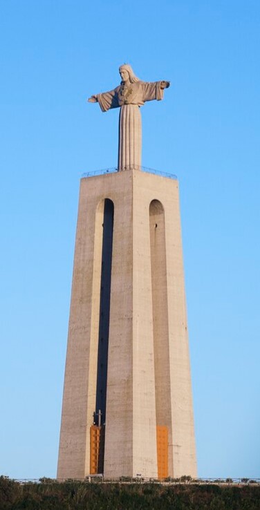
The construction of the Christ the King monument was approved on 20 April 1940, as a plea to God to release Portugal from entering WWII.
The monument consists of a 82 meter pedestal with a 28 meter image of Christ.
Perched on the opposite side of the river the figure of Christ has its arms extended out facing the city of Lisbon, as if to embrace the city.
Long story short, apart from the weather, Lisbon was fantastic and we will need to come back as there is so much more to explore and do. It became very clear that the time that we had allotted was insufficient for the amount to see and do. This was further hampered by the rain that kept us hiding more than exploring.
The prices are more than reasonable and the friendliness of the people was just amazing. And I think that both Jill and I can fit another egg tart or two in, and for the record, even the shitty ones remain good. And there is so much more that missed out on seeing.
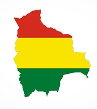
Bolivia is a landlocked country in South America that is bordered Brazil, Paraguay, Argentina, Chile and Peru.
The administrative capital (and seat of government) is La Paz. The constitutional capital is Sucre (the seat of the judiciary). While the largest city and main industrial center is Santa Cruz de la Sierra.
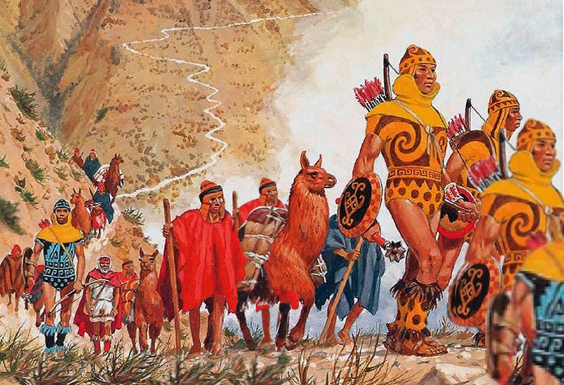
Before Spanish colonisation, the area that is now Bolivia was part of the Inca Empire. But in the 16th century, Spanish conquistadors took control of the region and found it to be rich in silver deposits. Spain built its empire, in large part ,upon the silver that was extracted from Bolivia’s mines.
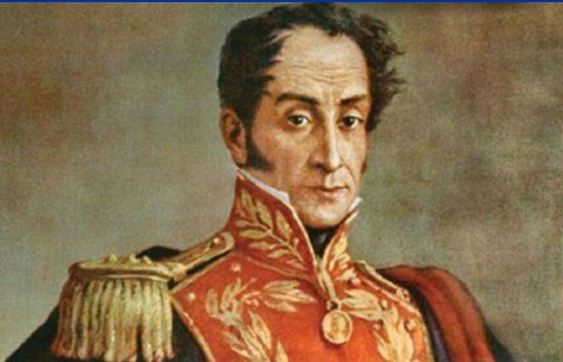
Bolivia was named after Simón Bolivar (officially José Antonio de la Santísima Trinidad Bolívar Palacios Ponte y Blanco) who was a Venezuelan leader that led the majority of South America (Colombia, Venezuela, Ecuador, Peru, Panama, and Bolivia) to independence from the Spanish Empire. Bolivia gained its independence in 1825.
Lake Titicaca is about the only thing I had heard about from Bolivia and we didn’t get near it. It is the largest lake in South America and sits high in the Andes mountains on the border of Bolivia and Peru. The western part of the lake lies within Peru while the eastern side is located in Bolivia, near La Paz.
Five major river systems feed into Lake Titicaca (Ramis, Coata, Ilave, Huancané, and Suchez) and more than 20 other smaller streams also empty into Titicaca. There are 41 islands on the lake, some of which are densely populated.
Most importantly, Lake Titicaca is the legendary birthplace of the Inca civilization, and is also believed to hold precious Inca treasure.
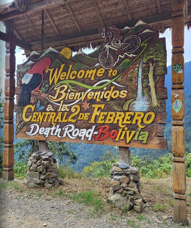
The other thing that I had seen about Bolivia was about the Yungas Road. This is more commonly known as death road. I had seen documentaries of cars, trucks and buses trying to navigate (and pass each other) on this stretch of road, often in pouring rain, with landslides taking place underneath vehicle tyres. All of this on the side of a cliff with inches to spare.
The steep slopes, lack of guardrails, narrow width of the road (3 meters in some places), weather conditions (rain and fog would reduce visibility), muddy terrain and loose stones made it the most dangerous road on the planet. It was infamous for its dangerous conditions and deaths. Before an alternate route was built it averaged 209 accidents with 96 deaths per year.
In July 1983, a bus fell from the Yungas Road into a canyon, killing more than one hundred passengers (I am still trying to work out how you get 100 people in a bus) in one of the worst road accidents in Bolivia. Until the mid-1990s, 2-300 drivers fell off to the cliff each year.
When it stopped being used as a vehicle road (due to the danger) it has now become a 60 km downhill mountain biking route between La Paz and the Yungas region.
Even as a cycle path, at least 18 cyclists have died on the road since 1998.
Santa Cruz de la Sierra
This mouthful translates as the Holy Cross of the Mountain Range and is the largest city in Bolivia, with a population of around 2.4 million.
The city was first founded in 1561 by Spanish explorers and remained fairly small until the mid-20th century.
But now it is the most important business center producing nearly 35% of Bolivia’s GDP, and receiving over 40% of all foreign direct investment in the country.
Our arrival here was great. We checked in to a local hostel that was right in the middle of things (restaurants, clubs and bars) and a relatively short walk (1.5 km) to the heart of town. Having arrived fairly late (and not that hungry) we settled into a local cafe for some refreshing beverages and a light snack. As it turned out our snack was quite considerable and our beverages were very refreshing.
As we finished up and returned home, a great storm hit that dumped rain for about the next 10 hours or so. So the next day we kicked back waiting for the rain to ease before starting our schlepp around the tourist sights in town. The first thing that we hit on the walk was the Parque El Arenal which is a park with a large lake, fountains, and an epic mosaic mural by artist Lorgio Vaca.
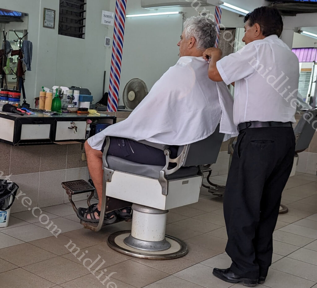
After the park I saw the local barber and decided it had been a while since I had been Manpered.
So I pulled in for a haircut and a straight razor shave.
I still highly recommend these.
Next stop was the main square (the Plaza 24 de Septiembre) which is a large square filled with plants, tall palm trees and benches. Until recently, sloths were hanging from tamarinds’ branches bordering the square. They are now in the zoo. And they had the coolest little old dudes wandering about in yellow offering to sell you a coffee.
The square is dominated at one end by the Cathedral Basilica of St. Lawrence.
The rest of the square is surrounded by government buildings and shops. There is an artisanal alley close by with very cool local handicrafts. Which i would have got some if space was not an issue.
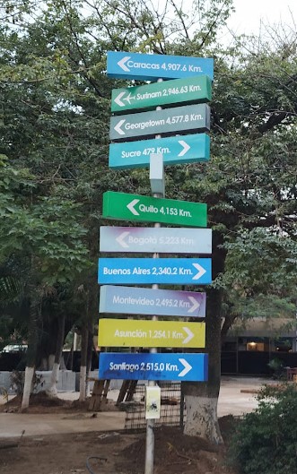
Plaza Calleja is a huge fizzer, billed as the centre of South America.
It is just a tiny park with the centre allegedly marked with a wooden cross and a sign with city names and distances.
If you take a good look at any map it is not really the at the centre of South America.
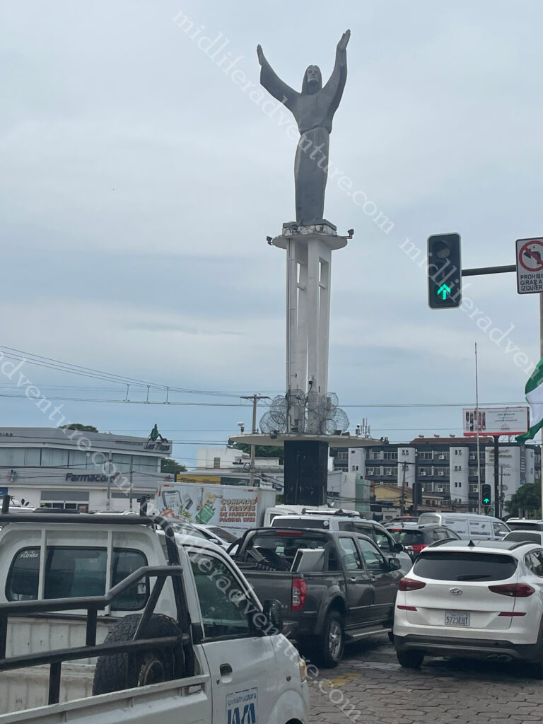
The tourist blurb billed a Christ the Redeemer, similar to Brazil, right here in Santa Cruz de la Sierra.
Needless to say we were underwhelmed when we found it holding up traffic as a roundabout, at a busy intersection, just North of town.
Having blitzed town we opted to take a private tour that cost us about $100 for the driver for the day but involved a 6am pick up and a whole day exploring with a 5:30 pm drop off. So for almost 12 hours of his time and the fuel and guidance $100 (for the two of us) it was a steal.
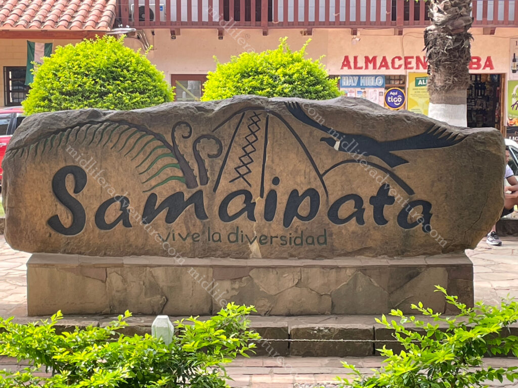
Samaipata
About 120 kilometres (and over 3 hrs driving) to the southwest of Santa Cruz de la Sierra in the foothills of the Andes (still at just under the height of Mount Kosciuszko) is the small town of Samaipata.
The town itself is seriously nice and small with colonial buildings and narrow cobblestone streets. The centre is set around a really nice, and seriously well used park, which seems to be the focal point for all activities in the tiny town (under 5000 people).
But the main reason for coming was to see the El Fuerte de Samaipata or Fort Samaipata. But before we did, a quick pop into the Archaeological Museum (a four room display) for a poke about (one $11 ticket does both) before heading up the mountain to see the main attraction.
But before you get to the site, you are met with some pretty spectacular mountain, farmland and jungle views from the foothills of the Andes.
This is a UNESCO listed pre-Columbian archaeological site. The site encompasses buildings of three different cultures: Chané (pre-Inca), Inca and Spanish. It is believed to have been started by the Chané but there are also ruins of an Inca plaza and residences, from the late 15th and early 16th centuries.
The archaeological site is about 20 hectares (49 acres) and is divided into a ceremonial sector and an administrative/residential sector. The ceremonial sector is a large rock (220 x 60 metres) that has been almost completely covered with carvings of both Inca and pre-Inca origin. At the highest point of the rock you find “coro de los sacerdotes” (choir of the priests) . This is 18 niches carved into the rock, that were believed to be seats.
The residential and administrative sector is believed to have been an Incan provincial capital. It has a large plaza about 100 metres on each side bordered by a “kallanka,” (rectangular building typical of Inca cities). The kallanka is 70 metres long and 16 metres wide and was typically used for public gatherings, feasts, and housing visitors and soldiers. The kallanka at Samaipata is the second largest in Bolivia.
Having milled about taking photos for a few hours we headed back to town for some well-needed lunch and a look around the tourist shops in the rain.
This was a fantastic day that saw us hiking up and down the side of a mountain and checking out some Incan ruins. I did not know it existed before now, but really loved the opportunity to get out and about amongst it.
About 35 minutes from Santa Cruz you can find the Biocenter Güembe Mariposario, which is a combined eco-park and a pool complex. The park is home to the world’s largest butterfly sanctuary and houses a diverse collection of orchids in its “orquideario“. There is an aviary where you can see scarlet macaws, toucans, parrots, peacocks and other colourful tropical birds, along with the odd monkey. Having seen birds, butterflies and not particularly being into pool developments we passed on this, but by all accounts it is ok.
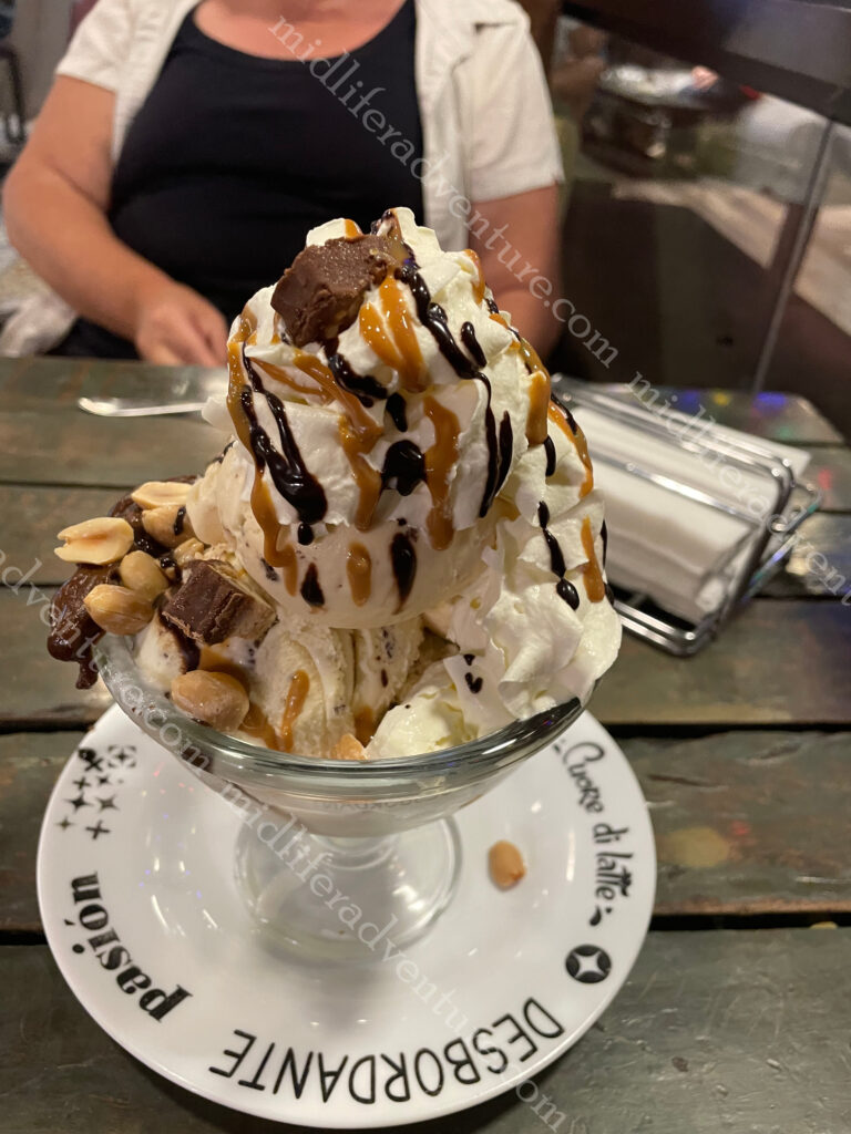
On our middle evening in Bolivia we had a very ordinary meal that we decided to top off across the road with an extraordinary dessert.
It was extremely decadent, totally unnecessary, over the top and was magnificent.
Well Bolivia has been great. This goes on the list of places to come back to to get up high in the mountains to La Paz and Lake Titicaca. We did not make it this time as time was tight and we both knew full well the effects of altitude after our earlier Everest adventure.
The next trip will include the long awaited Machu Picchu in Peru which sits at a similar elevation as Lake Titicaca and Cusco. If you want to play about at decent elevations we found last time around that it is best to spend some time acclimatising. So it may be a nice trip to bounce about at the 3500-4000 meter elevation level for a while doing so.
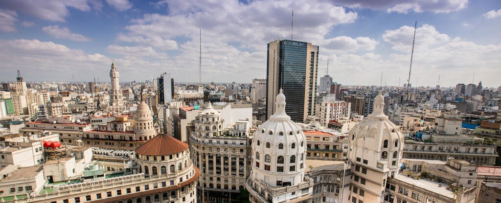
Buenos Aires is the capital and main city of Argentina. The city is located on the western shore of the Río de la Plata, on the southeastern coast. “Buenos Aires” is Spanish for “fair winds” or “good airs”.
According to the blurb it was the Spanish coloniser Pedro de Mendoza (in 1580) that established the first settlement there, which he named Nuestra Señora Santa María del Buen Aire (“Our Lady St. Mary of the Good Air”). Buenos Aires locals are referred to as porteños (“people of the port”) because so many of the city’s inhabitants historically arrived by boat from Europe.
Our arrival into Buenos Aires was similar to those, and we came in through the port. We were just one of several ships in that day, and to say that the port was bedlam, would be an understatement. We had teamed up with our dinner buddies (Kurtis and Mark) who had a thing for gardening, so we got out of the port and Ubered our way to the botanical gardens (for about $4).
I am much more a statue guy than a garden guy, and the photos clearly reflect that. That said, the gardens were nice, with the exception of the mosquitos that absolutely loved by high quality Aussie blood. There were trees aplenty and even a butterfly garden buried among all of the foliage.
To say that Buenos Aires is a dog friendly city would be an understatement. The sheer number of dogs in public parks and on leashes wandering the city was astounding. And these pooches are seriously pampered.
Sadly the wealth and influence of the city far overshadows the rest of the country. But as with all cities Buenos Aires also reflects Argentina’s economic and social problems. Homelessness and drug use were evident, although at no point did we feel unsafe or uneasy.
After the gardens we found a few little holes in the wall that fed and watered us for a ridiculously cheap price. Jill and I had 3 empanadas each washed down by a pint of the local brew (and a sampling of some others – including an on tap gin and tonic) for the princely sum of $8.40. After that we found a local deli and then a bakery, damn I think I might be falling in love with Argentina.
One of the major attractions of the city is the Recoleta Cemetery. In 1822, the former garden was turned into the first public cemetery in Buenos Aires. Known as the “city of the dead” or “city of angels”, Recoleta cemetery has a layout similar to a city with one main street, diagonals, narrow corridors and internal passageways.
It is set in an area of 5.5 ha (14 acres) and you will find around 4800 vaults and mausoleums. The cemetery is more of an open air museum than anything else. As soon as you walk through the doorway you are met with amazing architecture, works of art and sculptures.
More than 20 presidents, 25 city mayors, 40 governors, Nobel prizes, writers, politicians, engineers and even a caretaker are buried at Recoleta cemetery. But the most famous is that Recoleta Cemetery is the resting place for María Eva Duarte de Perón (known as “Evita”).
Outside the cemetery is a park known as Intendente Torcuato de Alvear. This area turned into a huge market on day two of our exploring.
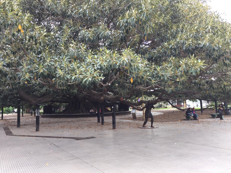
Plazoleta Chabuca Granda (the oldest tree in town) also sits in the square outside the cemetery. It even has a statue of a dude holding up one of the super heavy branches.
Just next door to the cemetery you can find the Nuestra Señora de Pilar church. Built in 1732 it is one of the oldest in the city.
In reality I got a bit turned around when exploring here. On day one we were at the cemetery and on day two we were at the Nuestra Señora de Pilar church (to follow). In reality these are side by side but I entered and exited the cemetery from the same way and did not even realise this. The next day we came at it from the opposite side and took a photo of the church that I had almost sat on the steps of the day before.
Buenos Aires is an amazing city with wide avenues and a true cosmopolitan flair that feels more European than Latin American. There are some huge colonial landmark buildings but the real feel of the city is the differences between the individual neighbourhoods. Each one has its own distinct feel and have their own meeting places, generally coffeehouses or bars.
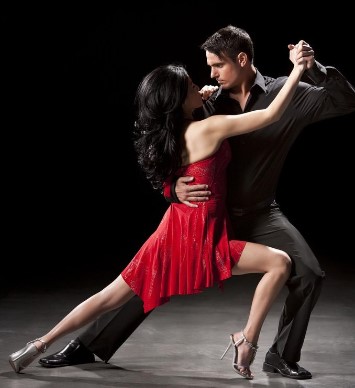
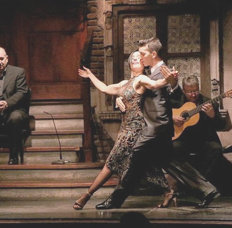
At night Buenos Aires’s nightclubs (boites) come alive as people flock together to dance the tango.
This famous dance originated in the lower-class areas of the city and is said to ‘reflect the soul of the Argentina’.
While we didn’t go to a tango club, the ship did bring some of the best dancers on board that evening to put on a show.
If you want to do the full tourist thing there are any number of these boites that will offer you dinner and a tango show.
But in reality, if you wander about a bit at night, you almost cant help but run across random tango breakouts.
As we were in town for two full days and day one was taken up with gardens and the cemetery, day two saw us hitting the major sights and the neighbourhoods. Lets say up front, two days was not enough. But it was what we had, so we hopped a cab ($5) to Plaza de Mayo which is the oldest public square in Buenos Aires.
The square is named after the Argentine revolution, which began on 25 May 1810. It has been the scene of many of the most important events in the city’s history, from the second founding of the city in 1580, through the revolution of independence, to more recent political demonstrations.
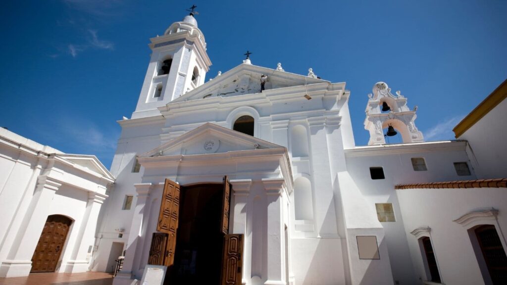
Around the square are several important buildings: the Cabildo (old town hall now national museum), the Metropolitan Cathedral (where Pope Francis conducted mass for 20 years), the Casa Rosada (Pink House or Presidential Palace and site where Evita gave some of the more famous speeches), the national revenue office, the national bank and the intelligence secretariat.
As a random bit of knowledge, apparently, they used to do a version of running of the bulls in the square, prior to the revolution.
The Pirámide de Mayo is at the hub of the Plaza de Mayo and is the oldest national monument in the city.
It’s construction was ordered in 1811 to celebrate the first anniversary of the May Revolution.
It was renovated in 1856 and in 1912 was moved 63 metres with the idea that a much larger monument would eventually be constructed around it.
Having done the plaza we walked past the bank and along one of the many parks to explore the city more fully. We wandered along wide avenues and took in the interesting mix between the old and new parts of the city.
La Boca is a colourful neighborhood of Buenos Aires that is characterised by the street artists, narrow streets and brightly painted buildings. In the middle of La Boca is Caminito, a narrow alley flanked by zinc shacks that reflect the district’s early immigrant days. Caminito is more of a street museum than a traditional alley and the area gathered significance as the inspiration for the music for the tango “Caminito (1926)”.
Asado is the term used for South American barbecue. This type of meal is common in Argentina, Chile, Paraguay, Peru and Uruguay and usually consists of beef, pork, chicken, chorizo, and morcilla (blood sausage). These are cooked on an open fire or grill (called a parrilla) and usually eaten with side dishes and red wine.
Buenos Aires is the city with the highest number of football stadiums in the world. The city has at least 18 professional teams, and the passion for the sport is visible on almost every street corner.
The passion of Argentine football fans is legendary creating an electric atmosphere at each game. The fans choreograph chants, design tifos (giant displays), and ignite the stadium with their undying passion. When doing some research I found the following “Argentine football stadiums are not just structures made of bricks and cement. They are temples of passion, history, and culture. Each corner echoes with tales of legendary matches, iconic goals, and unforgettable moments. Every seat has witnessed emotions ranging from the ecstasy of victory to the heartbreak of defeat.”
How can you really argue with that.
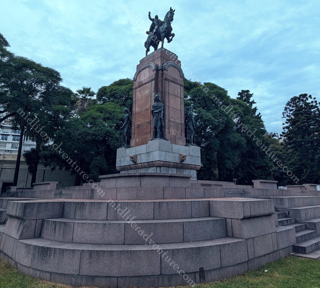
Our last part of the day involved a run down the hill from the cemetery past the Recoletta, through the park (and the market), past the statue in honour of Carlos María de Alvear a military revolutionary (and the towns first mayor).
Across the bridge, through the park, past the bizarre statues of kangaroos and to the massive law school building. I tried to get the story behind why there were kangaroo statues in Buenos Aires but had absolutely no luck.
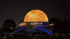
We didn’t get here but in the Parque Tres de Febrero you can find the 1960s-built planetarium. Looking like a UFO it has projection room with a 20 meter dome and reclining seats for viewing projections of the stars.
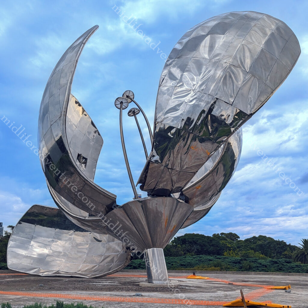
And our final port of call before heading out of town was to the Floralis Genérica. This is a sculpture made of steel and aluminum located in Plaza de las Naciones Unidas (United Nations Plaza) that was donated to the city by the Argentine artist.
Buenos Aires was amazing. It was neat, clean, friendly and extremely cheap. Meals, taxis and ubers were all incredibly cheap and we have already decided that we will be coming back here many more times.
Travelling the world in a pre and post COVID state